Antarctica Ahoy!
Around Scott Base
Expedition Begins
Exploration Area
Exploration Routes
Plateau Loop map
Polar Plateau
Icy Panorama
East Quartzite Range
West Quartzite Range
Upper Glacier
Glacier Route
Middle Glacier
Lower Glacier
Final Stretch
Destination
Conclusion
Diary: Introduction
Diary: Preparation
Diary: Polar Plateau
Diary: Quartzite Xmas
Diary: Into the Glacier
Diary: Home Run
Appendix: Polar Life
Appendix: Logistics
Appendix: Mapping
Thanks

Tararua Antarctic Expedition, 1962-63
Polar Plateau
![]()
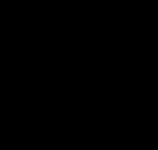 Evan and John haul their 300 kg sledge.
A mile an hour (1½ kph) is a brisk pace on the flat.
Uphill man-hauling is slower and exhausting.
Alan Beck of the 1957-58 Tucker Glacier Expedition
said of man-hauling:
"Shut yourself off from the world,
and heave each step in a trance.
Don't count minutes or watch the country,
as both pass so slowly."
![]()

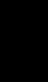 Lunch break from man-hauling. 10 December.
We marched for 50 minutes per hour,
resting for an hour at lunch.
Long, strenuous days in the cold, dry air
made us thirsty. Vacuum flasks kept beverages
from freezing. Half-liter flasks proved rather
small, so we drank copiously at camp.
![]()

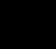 The sledge carried a 300 kg load:
food, tent, bedding, clothing,
personal items, equipment for
camping, climbing and surveying,
and a radio transceiver.
Norwegian-designed Nansen sledges
have wooden members lashed together,
a resilient construction.
![]()
Each 20-man-day standard ration box held 16½ kg of food:
dehydrated meat, vegetables, soup, egg, milk and beverages,
as well as pemmican, bacon, oatmeal, Tararua lunch biscuits,
tinned butter from Argentina, Nestlé's chocolate and toilet paper.
![]()

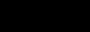
Geological team Evan Leitch and John Hayton at work,
near survey station H2. 13 December. Camp III.
Geological mapping and navigation
rely on a magnetic compass for direction.
Near the south magnetic pole the earth’s magnetic field is faint,
so the magnetic compass was of little use,
which hampered both scientific work and navigation.
![]()