
|
|
           |
The Surname Washam is the 10,143rd most popular last name (surname) in the United States; frequency is 0.001%. (U.S. Census Bureau) Washum is the 66,595th most popular last name (surname) in the United States; frequency is less than 0.001%. (U.S. Census Bureau) Wisham is the 29,436th most popular last name (surname) in the United States; frequency is less than 0.001%. (U.S. Census Bureau) Warsham is the 59,236th most popular last name (surname) in the United States; frequency is less than 0.001%. (U.S. Census Bureau) Worsham is the 4,709th most popular last name (surname) in the United States; frequency is 0.003%. (U.S. Census Bureau) Worsham Soil: Worsham silt loam is a poorly drained soil that occurs along the foot of slopes and upper drainage ways. It is formed from fine soil materials which have washed from the Piedmont uplands. Located in the southern part of the Piedmont Plateau in Virginia, North Carolina, South Carolina, Georgia, and Alabama. Most of the Worsham soils are in woodland or pasture, and only a very small amount is in crops. Crops are corn, soybeans, sorghum, and mixed hay. Native vegetation is sweetgum, blackgum, willow oak, pin oak, alder, elm, willow and other species or water-tolerant plants and some pine. Surname Geographic Locations England Worsham - The earliest record of the name Worsham appeared as a place name in Sussex, England. A charter, dated 772 makes reference to the village Worsham as being one of the "8 hides in the place which is called Bexhill." A hide was an area of 60 to 120 acres where a family or group of people were living. The charter appeared in a Canterbury register compiled about 1300: "In the name of our lord God and saviour. What is done for this world barely lasts until death, but what is done for eternal life remains forever after death. Therefore it is for everyone with deep forethought of mind to ponder and consider how with the fleeting possessions of this world he may obtain for his treasure the abodes of heavenly promise. Wherefore I, Offa, king of the English, for the good of my soul and for the love of God, and in accordance with my former promise grant in eternal possession to Almighty God (and) to the venerable Bishop Oswald a certain piece of land in Sussex, so that it may be seen to serve the praise of God and the honor of the saints, that is, 8 hides in the place which is called Bexhill as set forth in the bounds. These are the bounds of the 8 hides of inland of the people of Bexhill. Firstly at the servants' tree, from the servants' tree south to the treacherous place (?), so along the shore over against Cooden cliff, eastward and so up on to the old boundary dyke, so north to Kewhurst, and so to the Benetings' stream, and so north through Shortwood to the boundary beacon, from the beacon to the bold men's ford, from the ford along the marsh to the road bridge, from the bridge along the ditch to Beda's spring, from the spring south along the boundary thus to the servants' tree. These are the gafolland of the outland of Bexhill, in these places which are called by these names, at Barnehorne 3 hides, at Worsham 1, at Ibba's wood 1, at Crowhurst 8, at Ridge 1, at Gyllingas 2, at Foxham and Black Brooks 1, at Icklesham 3, with all things pertaining thereto, fields, woods, meadows, fisheries. Let the aforesaid land remain from this day, given as I have said for me in the name of God, free from all royal exaction's and bound to the use of those serving God, but on this condition: that after his day, this gift be returned to the Episcopal see which is called Selsey. If anyone at any time in great or small degree dares to reduce this gift made by me, let him know that he will incur the penalty for his presumption in the stern judgment of the all-powerful God, and will not escape from a bad hearing. These are the bounds of Icklesham, to the pool in the hollow at the cliff, out on to the middle of the brook, so to Tatta's corner of land, to the moor, to Eadwine's valley as far as the boundary of Kent, then west along the middle of the bathing (?) brook. This chart was written in the year 772 from the incarnation of our Lord Jesus Christ, the 10th of the indiction, on the 15th day of the month of August. I, Offa, king of the Mercians, as the power was conceded to me by God who reigns, have confirmed this charter of gift, signing it with my own hand, and placed the sign of the holy cross. I, Ecgberht, king of Kent, have agreed and signed, I Jaenberht, archbishop by the grace of God, have signed. I, Cynewulf, king of the West Saxons, have agreed and signed this gift. I, Eadberht, bishop, have agreed and signed. I, Oswald, bishop, have signed the gift made to me. I, Righeah, bishop, have agreed. I Diora, bishop, have signed. I, Oswald, alderman of the South Saxons, have agreed. I, Osmund, alderman, have confirmed. I, Aelfweald, alderman, have acquiescent. I, Oslac, alderman, have signed. And these witnesses were also present whose names are written below: Botwine, abbot, Eata, Heahberht, Brorda, Berhtwald, Esne, Huithyse, Baldraed, Bryne, Stidherht, Cyne, Ealdraed, Lulling, Berht, Byrnhere, all the shire; Aemnele, prefect. All these agreed, signed, and confirmed. These are the land boundaries of Barnhorne, firstly at the mossy spring, from the spring south into the valley, from the valley up on to the little heath, to the goblin's spring, so south and east to the old road, along the road to the old boundary mark which stands on the east side of the road, to the deep valley, to the reed pond. From the pond to the five roads, and south to the red ditch, along the ditch to Picknill, and so south by the eastern moor to the angle, so east to the yew enclosure, so north to the wood, and so south to Cyll'as hill, from the hill to Cylla's spring, west along the stream to Thunor's clearing, and so west along the stream on the outside of the salt marsh, and so north to the black brook, up along the stream to the swine enclosure. North along the boundary to siferthingc sterfa, and so north to the muddy ford, and so up on to the old dyke, eastwards along the dyke, and thus to the mossy spring." On the 1610 English map of Sussex by John Speed, the village of Worsnam appears midway between Hastings and Bexill, inland about a mile and a half, and a half mile south of the present day village of Hollington. Wartling lies about eight miles to the west. From these 19th-century maps it appears that there were three farms, Upper, Lower and Little Worsham, with the possible addition of a vanished Great Worsham, and there was a mansion. "Great Worsham Mead", the name of the large field south of the road 300 yards west of Little Worsham Farm. The Bexhill Observer of March 15, 1958 reports on the demolition of the Old Great Worsham farmhouse, which was built about 1719 on the west of Pebsham Lane and about one mile southwest of Worsham Manor. The farmhouse was said to have dated from the 1500s. The Ordnance Survey map published 1878, six inches to one mile, shows Upper Worsham Farm, Little Worsham Farm and Pepplesham Farm about l/4 mile from each other in a triangle about one mile northeast of Bexhill, Sussex. On the map (date not recorded) "The Chronicle" there is a Worsham Bottom, Worsham Mill & Worsham Tavern at Asthall Parish, Oxford, England. Worsham, Oxfordshire Co., England Stonefold Worsham Lane, Oxfordshire Co., England Worsham Reservoir in England Worsham Lane in Bexhill-On-Sea, East Sussex Co., England Washam, Denbighshire, North Wales ca. 1870
Arkansas Washam School (historical), Faulkner Co., AR California Worsham Creek is in Los Angeles Co, CA Worsham Canyon is near Whittier, CA Georgia Worsham Lake, a reservoir, is in Twiggs Co, GA. Indiana Washam Ditch, a canal, is in Indiana Kansas Washam Cemetery, Lincoln Co.,
KS (near Westfall) Kentucky Washam Lane, Wayne Co, KY, latitude: 365004N, longitude: 0845157W (US Census TIGER Files) Washam Road, Graves Co, KY, latitude: 365015N, longitude: 0882932W, variants: Ernest Cox Road (US Census TIGER Files) Worsham Theatre is at the University of Kentucky Student Center, Lexington, KY. Louisiana Spigener-Washam Cemetery, Union Co., LA Worsham Crossing, a town, is in Winn Parish, LA location is 31°45'38"N & 92°43'26"W; elevation is 153 feet. Mississippi Worsham Creek is in Grenada Co, MS. Worsham Creek is in Montgomery Co, MS. Washam Cemetery or Worsham
Cemetery, Wayne Co., MS Worsham Creek, Yazoo Basin, MS Missouri Worsham Post Office, Wright Co., MO; Worsham was a PO established in 1887. North Carolina Washam Rd. in Moorsville, NC Worsham Mill Road near Ruffin in Rockingham Co., NC Oklahoma Warsham Creek is in Lincoln Co, OK. Oregon Worsham Butte is a peak in Malheur Co, OR. Tennessee Worsham is a rural community in Sumner Co, TN. Also known as Shackle Island. Worsham Hollow is a valley in Giles Co, TN. Worsham Spring is in Robertson Co, TN. Worsham Cemetery, Robertson Co., TN Washam-Dykes Cemetery, Union Co, TN Texas Worsham Elementary School, 3007 Hartwick Road, Houston, TX Worsham, Texas is in Reeves County; location is 31°21'46"N 103°31'47"W is a transport point. Worsham, Texas, from 1879 – 1930, On 21 Jun 1880, Robert D. Rector was Postmaster of the Worsham Post Office in Wilbarger County, Texas. The Post Office was discontinued [date not given]; and papers moved to Vernon. Washam Cemetery,
Austin Co, TX Virginia Worsham, Virginia is in Prince Edward Co.; location is 37°13'48"N & 78°26'36"W; elevation is 472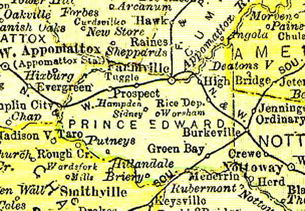 feet.
Worsham was named after Branch Jones Worsham who was Prince Edward County Clerk
for 53 years from 1816-1869. His portrait hangs in the Clerk's office at
Farmville. Location
of Worsham is illustrated on this 1895 map of Prince Edward County, Virginia. feet.
Worsham was named after Branch Jones Worsham who was Prince Edward County Clerk
for 53 years from 1816-1869. His portrait hangs in the Clerk's office at
Farmville. Location
of Worsham is illustrated on this 1895 map of Prince Edward County, Virginia.
Worsham Baptist Church, Prince Edward Co., VA, also known as Worsham Mission Church, Established 1950.
Worsham Cemetery, Washington Co., VA
Wyoming Washam is the county seat of Sweetwater Co, WY. The name Washam is for the part of the Henry's Fork valley where the creek joins Green River. It was named for David Holt Washam "Dave" an early day homesteader. By 1916 the following homesteads had been settled: David H. Washam, Robert Swift, Shadrack J. Large, Ida Franklin, Rosina E. Solomon, Oliver J. Wade, William Nelson, John Wade, John T. Despain, Jr., George Potter, John and Melissa Despain, Sr., Richard Son, James Twitchell, Thomas Quireing. Washam Spring is in Sweetwater Co., WY Washam Wash, a valley, in Sweetwater Co., WY Jim Washum Spring in Sweetwater Co., WY, probably named for David Washam's brother, James Harvey Washam "Jimmy".
© 1999-2002 by Larry E. Washam |
|
|


