 |
|
Guides - Mayon Volcano
Mayon Volcano Climbing GuideA Dangerous Beauty
Anyone wishing to attempt a climb of this mountain should first contact the Department of Tourism office in Legazpi City (Tel: (052) 482-0712 / 482-0813). The DOT representatives are experienced climbers and keep in close contact with PHIVOLCS regarding volcanic activity. The DOT can arrange for guides (necessary) and porters and provides comprehensive information. Since the unpredictable nature of volcanic eruptions and unstable slopes compounds the dangers inherent to climbing, climbers do so at their own risk and are responsible for their material and physical preparation. The Legend of MagayonLegends attempts to unravel the mystery of the origin of this magnificent chunk of earth. It seems that there once lived a very beautiful native princess who had an uncle named Magayon. He was so possessive of his niece that no man dared to challenge his wrath by courting the favors of the young maiden. One day, however, a brave and virile warrior was so smitten by the princess that he threw all cares to the wind, clambered up through the window of the royal chamber and enticed the girl to elope with him.With Magayon at their heels, the couple prayed to the gods for assistance. Suddenly from out of nowhere, a landslide buried the raging uncle alive. Local folks now claim that it is Magayon's anger bursting forth in the form of eruptions. See link to another Magayon legend below. Scaling Mayon, the Living MountainExperience the challenge of traversing different terrains with varying degrees of difficulty: part forest, part talahib grassland, part desert of rocks and boulders. MAYON VOLCANO (2,460 m) -- one of the most exciting mountains to climb in the Philippines; beautiful to behold at a distance yet behind the graceful symmetry of its slopes lurk hidden perils. Its rocky borders may be dislodged with a careless foot and turn into a dangerous avalanche.There are two basic approaches to the peak, from the Mayon Skyline Hotel (previously the Vista Lodge or Resthouse) north of the crater, or the Buyuhan (or Buyuan/Buyuon) Trail from the southeast. Which approach, if any, is safest at any particular time should be checked at the DOT office as well as the availability of transportation to the jump-off points and guides. The northwest approach to the crater starts at 762 m above sea level on a ledge where the Philippine Institute of Volcanology and Seismology (PHIVOLCS) Observatory and the Mayon Skyline Hotel are located. The Observatory and Hotel may not always be manned or open. A narrow 8-kilometer paved road links the place to the main highway. Private transportation may be required.
At slightly above 1,524 m where water becomes scarce, Buang Gully branches out into two canals. The left fork leads to the transition line at 1,921 m where the grassland ends and the rocky slopes begin. This spot is ideal for a campsite since it is near enough to the summit yet far enough from poisonous fumes which sometimes snakes down the slopes with a sudden shift in wind direction.
After scrambling over rocks and boulders, a cliff
system is reached at 2,195 m. A 40-degree ascent on loose volcanic cinder
and lava sand follows. And finally--the summit.
Northwest Approach (Buang Trail)DAY 10700 Breakfast at hotel. 0830 Make travel arrangements at hotel or take public bus from Legazpi to Mayon Skyline Hotel. 0930 Arrive at Tabaco. Proceed to the hotel. 1000 Make arrangements for accomodations (if available) or camping. 1100 Spend the rest of the day picture-taking.
DAY 2
DAY 3
DAY 4 Note: Some climbers, including Dr. Chris Newhall, a U.S. government volcanologist, have told me they are able to reach the summit and return to the Lodge in one day. This is recommended only for experienced climbers familiar with the mountain. It appears the 4-day schedule can be shortened to 2 or 3-day climbs depending on experience and conditioning. Southwest Approach (Buyuhan Trail)This approach is often the better of the two approaches. The jump-off point is near the village of Buyuhan (or Buyuan). It can be either a 2 or 3-day climb and the best approach should be determined with the help of the DOT office and your guides. There are two camps: Camp 1 (800 m; 3 hours) and Camp 2 (1800 m; 4 hours). Camp 1 has a hut and water source while Camp 2 has neither. Rainwater in depressions is usually available at Camp 2. From Camp 2 to the summit is another 3-4 hours. Give yourself enough time to make it back to camp before dark. Special Considerations
Other related links on this site:
Take me back to Bundok's Guides Page HTML Coding and Original Material Copyright © 2005 by Robert Gardner |
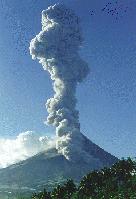 Mayon's
name comes from magayon meaning "beautiful" in the local dialect and a
dangerous beauty it is. It is the most dangerous, and at the same time,
the most compelling of volcanos in the Philippine landscape. After
eruptions in 1993 that killed more than 70 people and caused the evacuation of
thousands, the Philippine Institute of Volcanology and Seismology (PHIVOLCS)
designated a 6 km radius surrounding the peak as a Permanent Danger Zone;
off-limits to the general public. Still, travelers and mountain climbers
brave the wrath of Magayon to scale the most beautiful mountain in the
Philippines.
Mayon's
name comes from magayon meaning "beautiful" in the local dialect and a
dangerous beauty it is. It is the most dangerous, and at the same time,
the most compelling of volcanos in the Philippine landscape. After
eruptions in 1993 that killed more than 70 people and caused the evacuation of
thousands, the Philippine Institute of Volcanology and Seismology (PHIVOLCS)
designated a 6 km radius surrounding the peak as a Permanent Danger Zone;
off-limits to the general public. Still, travelers and mountain climbers
brave the wrath of Magayon to scale the most beautiful mountain in the
Philippines. From the Observatory, the trail creeps upwards through
a tropical secondary forest, which is replete with a wide variety of flora
and fauna. It then cuts across a talahib wilderness and swerves at
approximately 1,220 m towards Buang Gully, a ravine formed by ancient
molten lava flow. On the gully's floor are depressions containing rainwater.
From the Observatory, the trail creeps upwards through
a tropical secondary forest, which is replete with a wide variety of flora
and fauna. It then cuts across a talahib wilderness and swerves at
approximately 1,220 m towards Buang Gully, a ravine formed by ancient
molten lava flow. On the gully's floor are depressions containing rainwater.