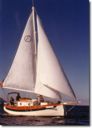
 The Comfortable Pocket Yacht
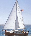
|
|
|
Flicka Sailing
|
Tarpon Springs To The Florida Keys I had planned to sail in the Florida Keys for the winter season and the first real cruise was slated to reposition Solar Wind from Joshua's Landing Marina in Port Richey to Long Key. This is a distance of about 250 miles and would cover much of the west coast of Florida. October is the time for the winter cold fronts and the accompanying northeast winds - perfect conditions for the planned cruise. The cruise was planned to maximize the amount of sailing time but I did carry 8 gallons of gasoline for the Honda 8 HP motor. This would be sufficient for about 80 miles of motoring in calm conditions. I could have chosen to follow the ICW from Tarpon Springs to Ft. Meyers for the first part of this trip. However, a quick check of the charts shows that the only real sailing opportunity using this route would be on Sarasota Bay. The remainder of the trip would be with the iron genoa and with the shoals at every turn, the trip would not be the most pleasant. Once at Ft. Meyers, the route would need to cover the "Miserable Mile" where the ICW travels from west to east and the strong tidal current sets north/south with shoals guarding both sides of the ICW. This did not sound like any fun at all. The alternative was to go on the outside in open Gulf waters and sail during the daylight hours while anchoring out in the open waters at night. Several opportunities did exist to reenter the ICW along the route for supplies, calm anchorages, or to rest. Once south of Ft. Meyers, there would be no option since the ICW does not exist along this area of the western Florida coast line. The advantage of the outside track was of course sailing time. Also, when on the outside, one anchorage in open water was pretty much the same as any other. I could therefore sail from dawn to dusk while on the ICW track would force me to select anchorages well in advance and stop as soon as I had arrived there even if that would mean losing several hours each day of travel time. I planned to sail down the coast to Cape Sable and then use a narrow passage named Yacht Channel to transit Florida Bay down to Long Key. Other commonly used routes exist and the published destinations from Marco Island include Key West and the Dry Tortugas. There is also a marked route to go from Cape Sable to Moser Channel and Boot Key Harbor as well as an entry point to the ICW located at Big Spanish Channel in the lower Keys. My destination for the winter was to be Long Key just south of Yacht Channel where I would keep Solar Wind in a slip at Sea Bird Marina. I have stayed in Sea Bird Marina before and it would be perfect for my needs. The marina is located at mile marker 69.5 on the bay side and offers easy access to the Atlantic via the Channel 5 Bridge. For Florida Bay sailing, the ICW is just a short distance away from Sea Bird Marina. Furthermore, the 10,000 Islands area is a two day sail to the north in case I wanted to further explore this area during the winter. Sea Bird is capable of handling vessels up to around 36 feet with drafts of around 6 feet in their deep basin and smaller vessels with drafts up to 3.5 foot in their shallower area. Sea Bird is relatively small so everything is on a space available basis and advance arrangements were made by phone (305-664-2871). Preparations I spent the week prior to my planned departure running down a check list of things I still needed. After provisioning, high on the list was a complete check of the safety systems and electrical systems. I needed to ensure that all running lights were still functioning and build up a set of spare bulbs for critical lights. This was not really a problem - just something I had put off doing. Last on the list was a check of the engine. The engine check turned out to be the most difficult task since no matter what I tried, it would not start. I finally pulled the cover off the motor and went over the fuel system to ensure that there was no blockage. This showed that there was fuel coming out of the top of the carburetor when I tried to start the engine. I had seen this before on my motorcycle and suspected this to be caused by a float or needle valve problem. A quick check with the local Honda dealer confirmed my diagnosis and the necessity to remove the carburetor for a cleaning. I was able to get the replacement gasket needed to effect this carbureator cleaning and repair from their stock. Three hours later, I was able to bring the motor to life with it's needle valve now moving freely. It had been 2 months since I had run the engine and the valve had stuck in place when the fuel in the motor had evaporated. On October 14th, everything was in readiness and I drove down from Port Richey and left my car with Sue and Joe (the owners of the marina). They stored my vehicle in their locked compound and I then picked up a vehicle from Budget Rent-A-Car at Marathon Airport for a one way rental back to Port Richey. I had called in to reserve the one way rental the previous week. The drive back to Port Richey was done the same day and I turned in the car at a near by Budget counter the following morning. October 15th I had planned to leave on the rising tide around mid day and then anchor out at Duchman Key in the lee of Ancelote Key off Tarpon Springs for the night. This would be a convenient departure point for the proposed voyage. While I managed to leave the marina on time, it was a less than graceful exit since I stalled the motor several times during the process and my send off committee was forced to hold lines and fend me off their boats while I worked to restart the motor. Once underway, I waved goodbye and proceeded out the river channel towards the open Gulf. This lasted about 5 minutes till my crew mate Mr. Murphy made his presence known by stalling the engine again. This time, there was no hope as I pulled repeatedly at the starter rope while watching myself drifting aground. Once firmly aground, I diagnosed the engine problem as being fuel supply related and found that the squeeze bulb on the fuel line was collapsed. Tracing the line back towards the tank I discovered that the tank side quick connect fitting had not opened properly. I was able to free the stuck internal spring with a little effort and this opened the fuel line again so that I was able to restart the motor. Since the tide was still rising, I was able to re-float myself with the aid of the motor and returned to the marina to do some more tests. My friends again held the lines while I ran the engine at various speeds for 15 minutes without failure. The tide still was rising so I once again said my goodbyes and turned for open waters. This time I made it to the Gulf and turned south the 10 miles to Dutchman Key where I anchored for the evening ( 28* 11.266' North, 082* 50.187 West), . I hoped that this less than perfect start to the voyage was not an omen of things to come. October 16th From this point forward, I expected to be pretty far from other vessels and basically on my own. My wife knew of my float plans and I would periodically update the plans by cell phone or email via Ham Radio. However, as the cautious type, two precautions were always taken. Firstly, I was never on deck without the belt type inflatable life jacket. Secondly, I was never out of the cockpit without using the sailing harness and jacklines. Even in the cockpit, the sailing harness was on whenever the boat was underway. At first light, I raised the sails even though there was little or no wind. I drifted slowly southwards and finally caught enough of a light breeze that I could set a course to make for open waters. It took about 4 hours before I was well clear of Ancelote Key and I could turn southwest with the intention of sailing till dark. At this point I was really starting to wish for a light air headsail since my 100% working jib was cut from heavy cloth and made up with sheets of 1/2 inch double braid. This jib has a reef point sewn in that would reduce it's area substantially. The main sail is equally heavy and equipped with three reef points. During the afternoon, I managed to make some progress as well as marvel at the antics of several dolphins that swam alongside for a look see. By evening, I was 8 miles off shore and opposite Johns Pass where I set the hook for the night in 30 feet of water (27* 48.831' North, 082* 56.126' West). The straight line distance covered was 22.7 nautical miles. October 17th My intention this day was to continue a southwest track in order to cross the mouth of Tampa Bay and it's ship channel about 10 miles off shore and well clear of the shoals west of Egmont Key. I would then then turn more southeast to sail closer in on the coastline for the following days. On raising sail this morning, I was greeted with a slightly better breeze and made good progress southwards. The winds remained at 5 to 10 knots most of the day and I crossed the ship channel at about 13:30. While I could have turned for the anchorage at Egmont Key, there was no reason not to continue southwards and anchor off shore again. My dolphin escort returned several times in the early afternoon but I was too occupied watching their play to take pictures. The breeze had picked up noticeably in the late afternoon and I was able to get just south of Longboat Pass before the approach of sunset encouraged me to set the hook for the day (27* 22.047' North, 082* 38.036' West). The straight line distance covered was 31.2 nautical miles. October 18th The weather forecast was for more of the same but the morning proved absolutely windless. I had the sails up but made less than one mile in a three hour time period. While I really did not have a set schedule, I had a goal of getting to the Keys by October 28th in order to return home in the first week of November. Time to make a sacrifice of a few gallons of gasoline to the wind gods and try to salvage a few miles of southward progress. I did see my dolphin escort again but this time they stayed further away. I motor sailed the rest of the day until I arrived off Venice in the late afternoon. I was not pushing the engine's capability - just a little above idle and estimated that my fuel consumption would be about 10 nautical miles per gallon at a speed of a little over 4 knots. By the time I arrived off Venice Inlet, there was a little wind and I was able to turn off the iron genoa and sail southwards to a point off Stump Pass where I set the hook for the day (26* 53.928' North, 082* 21.099' West). The straight line distance covered was 31.9 nautical miles with about 15 miles under motor sailing conditions. I tried to use my cell phone here to call home and give a progress report to the my wife but this proved impossible. There was no connectivity here even though I was relatively close to shore and population centers. However, my trusty Ham Radio based email worked like a champ and I was able to send my position and projected route home in order to avoid any anxiety on the home front. I continued to send emails at most anchorages and this proved as reliable as any cell phone. October 19th While the weather forecast remained the same, there was a better breeze this morning so I could turn 180* and proceed at an acceptable rate. However, by 13:00 this had died completely and I was once again staring at loosely hanging sails wishing for a light air genoa. I really wanted to reach the southern end of Sanibel Island by this evening so it was time to make another sacrifice of fuel to the wind gods. My dolphin escort returned several times this day and I did manage to get one photo of a near by approach while sailing. Motor sailing for half the day did add miles to the log so I was able to make my goal of setting the hook for the day at the southern end of Sanibel Island (26* 27.751' North, 082* 10.785' West). The straight line distance covered was 27.7 nautical miles. October 20th Today, the forecast was again for 10 knot winds and the morning breeze seemed to bode well for making southward progress. My route was crossing San Carlos Bay and anticipated a more or less direct path to Marco Island. I did not have sufficient fuel to motor the entire distance and making a fuel stop at a marina off Sanibel would mean a 15 mile detour to get around the shoals. I needed to get at least 1/2 way across the bay under sail power in order not to dip into my self regulated 2 gallon fuel reserve. Realistically, this crossing was expected to take two days under sail power. Fortunately, the morning breeze was slightly better than previous days and I made good progress to the southeast. About midday, I began to notice dead fish in the surrounding waters and within an hour, I had passed several miles of nothing but dead and dying fish all around me. I called the Coast Guard to report the fish kill on the VHF radio and their reply was that they were aware of it - the kill had been reported by fisherman that morning and was known to extend for almost 50 square miles. While calling the Coast Guard, I had been below and not watching my progress for a few minutes - no big deal since there was nothing on the horizon but dead fish. On returning to the cockpit, I once again turned southwest and made for Marco Island. This seemed impossible, no matter what point of sail I tried to go on, the light breeze seemed to have me rooted to one spot. I could make no progress at all in any direction. While strange, I decided to turn on the engine since I had now made sufficient progress towards Marco Island under sail that I could reach the anchorage that evening under motor power and still have 2 gallons emergency fuel reserve available. With the engine running, progress was slow - too slow. Something was definitely wrong. I turned off the engine and did a walk around on the boat - the anchor was still on the bowsprit - nothing else seemed wrong - why could I make no progress? Then I saw what seemed to be a black object next to the rudder - OK, I had hooked a crab pot. I then spent 30 minutes trying to get this @#$%^&*() crab pot off my rudder without success. I must admit that at this time, the thought of going off the boat with a knife in my teeth to cut the pot free did not seem too appealing. Here I was in the middle of something that had just killed off all the fish for 50 square miles and I needed to go swimming - not a good thing! In making preparations to go over the side, I lowered sails and prepared the various boarding ladders and backup devices. While doing this a lobster boat was approaching from the distance and by the time I was almost ready, they were pulling nearby traps. I hailed them and asked if this was their trap. As they approached my stern, their question was "What Trap - your rudder is free". It turned out that in lowering my sails, the trap was no longer being pulled up tight and was now free and 50 feet behind the boat. The lobster men pulled away with a good laugh and I was once again able to sail away with a heightened respect for crab traps and some much needed experience in how to get them clear. With 17 miles to go to the Marco Island anchorage, I now motor sailed the remaining distance and arrived there at sunset where I set the hook for the day (25* 58.342' North, 081* 43.413' West). The straight line distance covered was 38.3 nautical miles. This was the first night of the cruise in protected waters and I was at anchor off the main channel in about 8 feet of water along with three other boats. From Marco Island, there are two routes southwards. The first goes into an inside passage at Coon Key and is notoriously shallow. The other is a long trek west and south around the Cape Romano Shoals and then turning back eastwards toward the coast and Cape Sable. On inquiring of nearby boats, all said they planned to go on the outside rather than risk the shoals of the Coon Key passage. October 21st The morning's weather report suggested 10 to 15 knot winds from the North for Saturday and Sunday with winds building by Monday to Northeast at 20 knots from an approaching high pressure cell. The tide was already high and dropping with a new moon extreme low tide expected later in the day - not good conditions for the inside passage. I decided on making a run for Cape Sable and the Keys using the outside passage and if the winds turned too extreme, I would hide in the Little Shark River north of Cape Sable while I waited for a weather window to cross the last 25 miles of Florida Bay. I used the opportunity of nearby facilities to top off the fuel tanks with 6 gallons of gasoline and headed out of Capri Pass to the open Gulf and the Cape Romano shoals light. Sailing conditions were poor to say the least. I spent most of the morning becalmed and watching a pod of dolphins play and dive for their breakfast in the distance. It amazed me how clear the sounds of their breathing came across the still waters. By early afternoon, I was making better progress as the winds picked up a bit. By late afternoon, I was nearing the point where I wanted to turn southeast towards Cape Sable and making even better progress in a building wind. I had hopped to take advantage of the open waters in order to sail past sunset but this proved to be a very bad idea. By this time, the winds were 15 knots with gusts and I was thinking about putting in a reef or two. Sailing in the dusk was not too bad but once all light had disappeared, I could no longer really maintain a steady course. My compass was not lighted and the compass screen of the GPS was too insensitive to be used for navigation leading to wild fluctuations in my course. Using a flashlight on the compass worked but was really not too efficient given the building winds. Time to set the hook for the day (25* 34.213' North, 081* 36.161' West). The straight line distance covered was 25.0 nautical miles. The winds by now were considerably higher than I had expected and when I turned on the weather channels of the VHF I found a much different forecast. The winds were now expected to go to 20 knots with 3 to 5 foot seas this evening and build to 25 knots with 5 to 7 foot seas on Sunday. Not only was there a high pressure cell approaching from the north, but a building low pressure cell north of the Bahamas was interacting to strengthen the Northeast winds considerably. As these two systems approached, winds were expected to continue building and advance forecasts were looking nasty. Small craft advisories were already posted in the entire area. I was now well off the coast of Florida and Cape Sable was more than 40 miles away. Furthermore, Cape Sable offers no shelter and is not a place to wait out a blow. The Little Shark River located 17 miles to the north of Cape Sable does have several protected anchorages so this would have to be my new destination. October 22nd At dawn, I came on deck to 15 knot winds and seas that looked every bit of the 3 to 5 foot prediction. The sailing harness on a pitching foredeck was a real comfort. I was able to raise the anchor but it was a real task given the conditions. I then spent the next 4 hours trying to make progress towards the Little Shark River with a double reefed main. It appeared hopeless - the wind was building and shifting eastwards with 4 foot seas still from the north. Time for a change in plans since at my current rate of progress it would take two days of tacking and pounding into the building seas to reach the Little Shark River. A quick check of the charts showed that I was currently 36 miles due north of the entry point to Big Spanish Channel. By selecting this route, I would make the southwards portion of my cruise immediately and then wait it out in the lower Keys till the weather cleared before making the last 30 mile due east to arrive at Long Key. This sounded great and I turned immediately to a course of 180*. For this course, I only needed the headsail and I just went flying along on an easy broad reach at about 4.5 knots. I did manage to hit three more crab pots but by this time I was getting better at working them free of the rudder. I had turned south too late in the day to make the 36 miles before dark. The building winds also would make night sailing foolish. I was faced with another night in the open waters but expected that Solar Wind was up to the task. When dusk arrived, I found myself 13 miles from the entry point to the ICW and promptly set the hook for the day (25* 02.998' North, 081* 31.794' West). The straight line distance covered was 35.7 nautical miles. October 23rd The winds continued to build during the night but conditions below were acceptable. By morning, the weather report indicated current conditions were 25 knot winds with higher gusts and 5 to 7 foot seas. A quick check on deck confirmed this was not an exaggeration. After strapping myself in with the harness and jack lines, I went forward to raise the anchor. This proved futile since I had made a mistake the previous evening and allowed the starboard mounted anchor to drop on the port side of the bobstay. I now had to try to pull 6,000 pounds of boat upwind against 5 to 7 foot seas with the anchor rode at a sharp angle. No amount of effort on my part proved effective. I considered motoring up to the anchor but the sea state would have made the prop continue to rise out of the water. In addition, there was the issue of fouling the prop on the rode or rudder and getting myself in even more difficulty. I did consider waiting it out here till the winds subsided but the forecast indicated that the seas were expected to build to 9 feet and this was just not something I really wanted to do. The end result was that I cut the anchor, 15 feet of stainless steel chain, and 250 feet of 5/8 inch rode free and turned for the channel 13 miles away. Sailing into the channel was not too difficult since I had passed this way several years before. I did manage to encounter several more crab pots and almost put myself aground once more before getting free of the fiendish devices. Once in shallow waters, the seas had calmed down and were best described as a steep chop. I motored down the channel and examined the possibility of anchoring in the lee of Little Pine Key but this really did not offer much in the way of shelter. The best shelter in the area would of course be Boot Key Harbor which was at this point about 12 miles away. The weather report for the Florida Bay waters around the lower Keys was 25 knot winds with gusts to 30 knots and small craft warning had been up for two days. Forecasts were for these conditions to continue for another two to three days at least. I was able to make eastwards progress towards Moser Channel and the entry to Boot Key harbor but several crab pots conspired to block the way. Each time I encountered one of these devices, I would need to shut down the engine and free myself from it's clutches. The interval was enough that I was blown several miles west before I could retrace my way east again. Eventually, I gave up this endeavor and turned west for Sunshine Key Marina located on Ohio Key. I had been there before and knew this to be a powerboat marina with a good ramp, great camping/RV facilities, hot showers, and most of all close to where I was. The best part would be that the trip to Sunshine Marina was down wind. I made the three miles to Ohio Key under bare poles with the engine at slowest idle while making 5.5 knots - what a ride! Unfortunately, when it came time to make the turn into the marina channel, there was no way to hold it. I should have started the turn 1/2 mile off in order to better judge the leeway. In this case, I failed by turning directly at the entrance to the channel and was immediately blown sideways onto the starboard side shoals. Nothing left to do at this point but call for a Boat US tow off the shoal. I had Towing Insurance and this would be covered under their policy. The tow boat arrived from Marathon about 45 minutes later and he had extreme difficulties turning in the channel with his 400 horsepower. The operator ended up going well out of the channel with extra tow rope and then simultaneously heeling Solar Wind over while pulling the bow out to deeper waters. This worked well and I was soon off the shoal and tied up at a slip in the marina for the night. That night, the wind continued to howl and gusts were reported in excess of 30 knots. The weather I experienced was a result of an unusual combination. A high pressure region was moving down from the north and a low pressure region developed and remained stationary over the Bahamas. The combination of one clockwise flow and one counter clockwise flow combined and directed these extreme winds at southern Florida. October 24th to the 28th I stayed in the slip at Sunshine Marina for almost one week while the winds slowly died down. Bus service in the Keys is limited to three trips a day by Greyhound. The nearest stop is 9 miles away at the Big Pine Motel and a cab ride to there from Sunshine Marina is easy to arrange. There is also a stop at Layton about 1 mile from Sea Bird marina. This service made it easy for me to get down to Long Key and retrieve my car for use during my stay at Sunshine Marina. Sunshine Marina is a large facility that emphasizes boat slips for the RV/Camping crowd that makes up the bulk of their customer base. Their ramp is large and deep and they have many slips. However, their slips do not have water, electric, or other utilities. Since Solar Wind is completely self contained and power is provided from the solar panels, this was not an issue. Once the winds finally died down, I motored the 30 some miles east to Long Key and arrived at Solar Wind's winter residence on the 29th of October. October 29th to November 2nd I spent a few days getting Solar Wind tied up, cleaned up, and settled in for a few months of well earned rest. I used this time to get reacquainted with Sue, Joe, and their facility. I'm pleased to see that things have remained somewhat the same since I was last here. Peg Leg, the injured White Huron still makes his rounds accepting a hand out or two. He has one leg intact but the other leg is cut off at the foot and ends in a knob. Shadow, the marina cat, is still hunting the area to keep the Gecko lizards under control. Any sailor arriving at Sea Bird can expect an inspection tour from Shadow where she will jump from the dock to your vessel and tour your facilities. Most of the time, she is successful at jumping back but please keep an eye out if she slips on your fiberglass deck and falls in. Mokisatima is still in residence (the name means prayer or peace and happy heart). Mokisatima is a female arctic wolf that Sue has hand raised since a 9 day old pup as part of a captive breeding program. Mokisatima's own offspring may eventually be part of a program that leads to their reintroduction to the wild. Lessons Learned 1) The email via Ham Radio worked every bit as well as could be expected. I was able to report my movements and keep in touch with the family and report my plans despite some offshore anchorages where cell phone service did not exist. 2) The sailing harness, life jacket, and jacklines were a nice security blanket when things really got rough. The experiences with the Flicka and how it handled under rough conditions will help me plan for future cruises. It is very true that this vessel will stand up to much more than I hope to experience. 3) Trying to rush a weather window was not smart. I should have waited out the approaching winds in the anchorage at Marco Island rather than trying to hurry down to the Keys. I did not allow for the possibility of the forecast being wrong by a day or two. 4) I have already re-rigged the primary anchor to be deployed from the stern. This will avoid some of the issues of working out on the foredeck when things are less than smooth. It also means that the anchor can be deployed from the cockpit rapidly when necessary. 5) Salt water supplied to the galley sink is a big plus. The 20 gallons of fresh water last much longer now that I don't waste fresh water for routine washing. A quick rinse with a small quantity of fresh water is good enough after getting things clean with salt water. 6) I have now determined that the piece of plastic material that keeps crab pots and similar lines from being caught in the rudder has broken off. I'll find and install a replacement prior to going out again. 7) While I don't plan on night sailing as a routine, I will make an LED lighting system for my compass. 8) Having towing insurance is really a good thing. This one instance saved me $400 after figuring in the cost of my annual premium. The unlimited towing insurance offered by Boat US is not truly unlimited. There is what amounts to a $1,000 cap per incident and the towing range is limited to a 25 mile radius from the site of the towing company. However, that is more than enough coverage for my needs. |
|
Copyright © 1999-2002 Jobst Vandrey |