After you turn right...
 From bridge bifurcation, the track is flat and sunny for about 5 minutes.
From here you can see part of Caracas city at south; at east is the sierra leading to Toma Quintero and at west lies Loma Serrano where Sabas Nieves is located.
 Then you'll get to a place where there is a sign telling that you are in the road to Quebrada Quintero. There the tracks starts uphill and wobbly, alternating with flat areas.
About 8 minutes after bridge you'll find a short but step stairway. There is an unobstructed line of sight to Caracas from there.

Do you want a map of this path?... then click here!.
After stairway you'll reach a turn from where you'll start to hear creek. In front of you there is a hill where you can see the ascending path from Quebrada Quintero to Pajaritos. 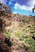
High tension power line tower at top of this hill marks the bifurcation leading to Toma de Quintero.
From this turn you'll start to get down until you find a creek. This is Quebrada Quintero. Few meters at your right there is a fall, and also take note that track goes on (to Pajaritos and Toma Quintero).
 On the other and, downstream you'll see another trail. This is the low path to Quebrada Quintero. That area has several small falls. If you've bring kids with you and they want to get down that trail, go with them. Don't let them alone because rocks are slippery, but also don't choke their eagerness to explore.
If you walk to the big fall, take note that in the back of its natural amphitheater exists a path ascending through rocks. That was the old path to get to top of fall, but this trail is now forbidden because it is too risky. If you want to get beyond fall, you should take another track.
 Editorial