Here you'll find details about getting to Toma de Quintero.
Access to this place shares the first part with trail to Quebrada Quintero, either you use high path or low path. So, this description start at that Quebrada.
 Starting the trip from the main fall of Quebrada Quintero, you have to walk eastwards (to Pajaritos).
To do so, cross the creek and take the ascending trail with a big rock in the middle and wood handrail.
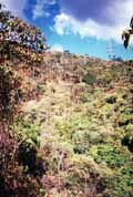 This trail is very step in some places, and climbs in zigzag the hill at east of Quebrada Quintero, shown at right. The key is to get to top, specifically to high tension tower up and right (click on photo to get a bigger image).
 From this area you can see Loma Serrano, with its ascending track to Sabas Nieves. Few feet remains to top.
Just before getting to bifurcation you'll see at right, about 5 feet from track, a small column of concrete that formerly supported a water pipe coming down from Toma de Quintero ("Toma" means "place where water is taken from").
 At right is shown bifurcation. However, please note this picture was taken coming from Pajaritos (opposite direction): The wide road is from where you came from, and the narrow one is the one you must take.
 Clicking here you'll get an interactive map of this area.
 Editorial