|
||||||||||||||||||||||||||||||||||||||||||||||||||||||||||||||||||||||||||||||||||||||||||||||||||||||||||||||||||||||||||||||||||||||||||||||||||||||||||||||||||||||||||||||||||||||||||||||||||||||||||||||||||||||||||||||||||||||||||||||||||||||||||||||||||||||||||||||||||||||||||||||||||||||||||||||||||||||||||||||||||||||||||||||||||||||||||||||||||||||||||||||||||||||||||||||||||||||||||||||||||||||||||||||||||||||||||||||||||||||||||||||||||||||||||||||||||||||||||||||||||||||||||||||||||||||||||||||||||||||||||||||||||||||||||||||||||||||||||||||||||||||||||||||||||||||||||||||||||||||||||||||||||||
|
HOME TABLE OF CONTENTS Acknowledge ments Report Contributors SECTION 1. SUMMARY SECTION 2. PROJECT AND WATERSHED DESCRIPTION SECTION 3. VOLUNTEERS AND COMMUNITY INVOLVEMENT SECTION 4. MEDIA AND PUBLIC EVENTS SECTION 5. ACID MINE DRAINAGE SECTION 6. WATER MONITORING SECTION 7. FISH HABITAT MAPPING PROGRAMS SECTION 8. REFUGE POND STUDIES SECTION 9. RESTORATION PROJECTS SECTION 10. FLOWS AND STORAGE REPORT SECTION 11. ENHANCEMENT CONTACT US
|
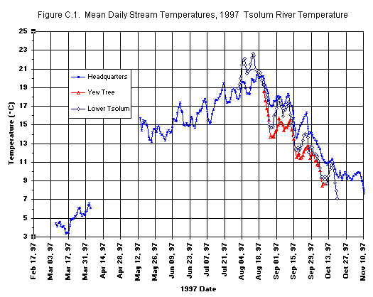
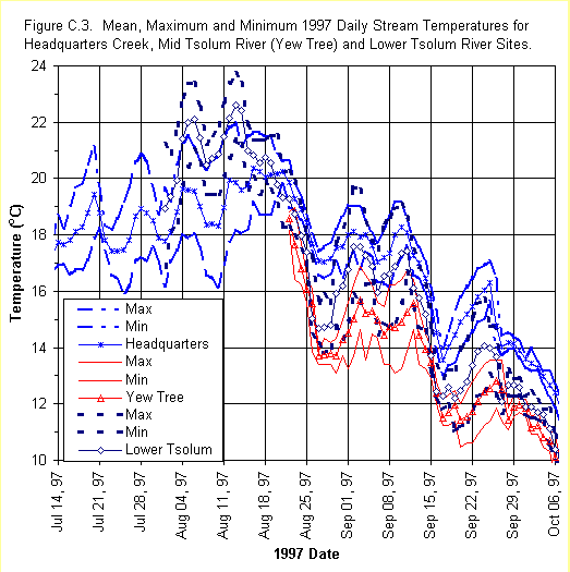
SECTION 6Water MonitoringTemperature MonitoringIn the summer of 1997 and 1998, water temperature data was collected from several sites in the Tsolum River watershed. The first objective of the study compared water temperature regimes in the Quinsam and Glendale Rivers with Tsolum River temperatures during pink salmon migration occurring in August and September.A second objective assessed the influence of stream flow supplements on stream temperatures. This analysis was conducted in collaboration with the ongoing water flows and storage study. The results of this analysis are presented in the 1997-1998 Tsolum River stream flows and storage study summary report. A third study objective evaluated and compared the temperature regime recorded at different locations in the Tsolum River watershed and developed a thermal profile for index sites at different locations in the watershed. The final objective evaluated differences in stream temperatures for the contrasting years of 1997 - a very wet year, and 1998 - a very dry year. The relationship between temperature and rate of development in pink salmon eggs incubated in the Tsolum River was previously reported by Heard (1991). This instream temperature study is complemented by an in vitro study of thermal effects on pink salmon egg survival underway at the Pacific Biological Station (PBS) in Nanaimo. The study will determine how high temperatures affect pink salmon egg survival. Present pink salmon egg transplant programs utilize stocks from the Quinsam River near Campbell River. This river has cooler water due to the influence of groundwater entering the river from Cold Creek. Utilizing stocks from warmer systems such as the Glendale River in Knight Inlet may lead to greater pink salmon survival in the Tsolum River watershed. In 1971, pink salmon eggs were successfully transplanted from the Kakweiken River, Knight Inlet, to the Tsolum River (Bams, 1976). MethodologyIn 1997, temperature sites were monitored on the mainstem at the lower Tsolum River (site 1), the mid-Tsolum River (site 4) and at Headquarters Creek at the hatchery (site 5). In 1998, four additional sites were added to the temperature monitoring study in Portuguese Creek (site 2), Dove Creek (site 3). Appendix A shows their locations.Two models of Onset Computer Corporation (OCC) miniature temperature data loggers: StowAway® TidbiT® and Optic StowAway® were used in the study (Appendix B). These single channel, waterproof, battery powered data loggers recorded temperatures every 15 minutes. The probes were protected by housings anchored to the shore. A companion device, the Optic Shuttle®, is used to download the digital data from the data loggers for export to a personal computer. OCC BoxCar Pro software is used to launch the data loggers and view and export temperature data files to other computer software. The temperature data loggers were periodically calibrated (April 1996, May 1998 and December 1998). A constant temperature bath was used for calibrating the data loggers with testing occurring at four to five water bath temperatures ranging from 1.3 oC to 26.8 oC. At the time of writing of this report, calibrations for all units were not yet completed. Data reported here is therefore preliminary with calibrated data to be reported in a future report. Figures C.1 and C.2 (Appendix C) relay the recording intervals for the seven different sites in the watershed, for 1997 and 1998, respectively. The data loggers located in Headquarters Creek (site 5) and at the Wolf Lake (site 6) outlet were operated year-round. Data downloading occurred weekly at sites 1, 2, 3, 4 and 5, while data was downloaded biweekly at sites 6 (Wolf Lake) and 7 (upper Tsolum at the Gun barrel). Access to these more distant sites required coordination with TimberWest work crews. Site DescriptionsSite 1. Lower Tsolum RiverMixed deciduous and coniferous riparian vegetation cover prevailed at the lower Tsolum River site. The data logger was attached to an old fish-counting fence in shallow water (12 to 15 cm summer depth) near the left bank, as viewed looking downstream. Site 2. Portuguese Creek The Portuguese Creek temperature logger was placed in a pool, of 1.2m maximum summer depth. With minimal summer flow, this pool became stagnant. The probe was attached to an overhanging tree root on the right bank, approximately 30 cm below the summer water surface level. Cattle fields border the stream on either side. Grass is the dominant riparian vegetation, interspersed with a few shrubs. Site 3. Dove Creek The Dove Creek temperature data logger site was located 100 m downstream of the Dove Creek Road crossing. This site is 25% covered by overhanging vegetation with mixed grass, deciduous shrubs and coniferous trees, with more shrubs present on the right bank. The data logger was attached to a tree root below an undercut bank in a pool (60 cm summer depth) near the right bank, suspended approximately 30 cm below the summer water surface level. Site 4. Middle Tsolum River (Yew Tree) The middle Tsolum River site, (also known as the Yew Tree) was located upstream of the confluence of the Tsolum River with Headquarters Creek. Both left and right banks of the river are densely vegetated and shrubs overhang the shallow pool where the logger was located. The logger was launched at a depth of about 18 cm in a pool with a summer water depth of 60 to 90 cm. Site 5. Headquarters Creek The average July to October 1998 stream depth at the Headquarters Creek temperature data logger site is 30 cm. This probe rests on a flat slab of hatchery raceway concrete on the left bank side. The right bank of the creek is covered with dense mixed riparian vegetation that provides some overhanging cover. There is no immediate riparian cover at the left bank. Site 6. Outflow of Wolf Lake As illustrated in Fig. B2 (Appendix B), the Wolf Lake temperature logger was located above the Wolf Lake dam on the right hand side of the outlet. This is where water flow from Wolf Lake to Headquarters Creek is measured. Vegetation is sparse and bedrock is the dominant stream substrate. The logger was kept 1 meter below the water surface. Site 7. Upper Tsolum River (Gun barrel) The most upstream Tsolum River data logger site was located at the Duncan Bay Main logging road crossing. Here the vertical bedrock at the right bank is 1.5 m high. Overhanging trees on both banks shade the large pool in which the logger was placed at a depth of 1.2 to 1.5 m. Weather Station An additional data logger was housed inside a weather station to record air temperature at Headquarters Creek Hatchery. Results1997 Temperature DataTemperature data were collected at three sites in 1997: Headquarters Creek (March 7 to April 4, May 14 to November 18), mid-Tsolum River (August 22 to October 22), and lower Tsolum River (August 1 to October 20). Appendix C contains the graphed results. Appendix C, Fig. C1 illustrates the 1997 mean daily temperatures for the three sites. Fig. C3 includes the daily mean, maximum and minimum temperatures for mid July to October. During the first half of August, site 1 (lower Tsolum R.) was warmer than site 5 (Headquarters Creek). In general, from August 22 to October 20, 1997, the daily mean temperatures are warmest at the site 5, followed by site 1 and site 4 (middle Tsolum R.). All three sites showed a similar pattern of temperature variation during the monitoring period. (Table C.1) Data displayed in Appendix C, Fig. C3,
shows that the differences in daily stream temperatures recorded in 1997.
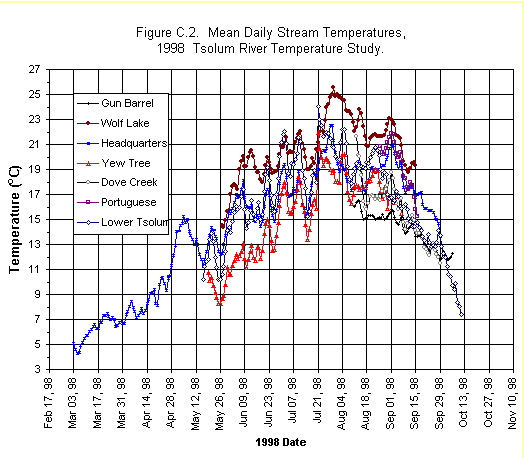
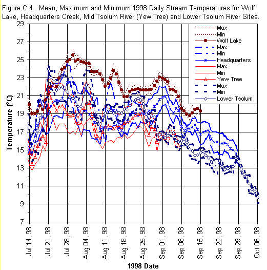
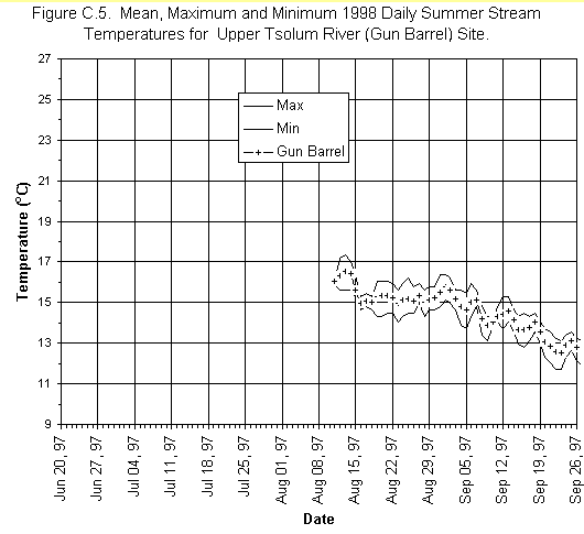
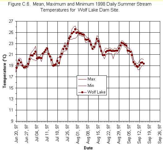
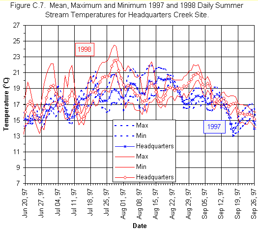
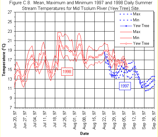
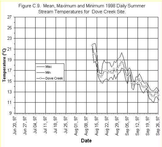
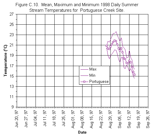
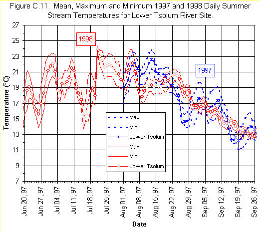
Table C2 (Appendix C) summarizes maximum, minimum, and mean stream site temperatures for 1998 monthly records. The 1998 daily stream temperature records are graphically presented in Appendix C, Fig. C2, and C4 to C11. The largest recorded daily temperature variations occurred over the summer period. Lowest temperature fluctuations were observed at site 6 (Wolf Lake) due to the moderating effect of the large volume of lake water. In order of the ascending range of daily temperature extremes the sites are: site 7 (upper Tsolum), site 1 (lower Tsolum), site 3 (Dove Creek), site 2 (Portuguese Creek), site 5 (Headquarters Creek) and site 4, (middle Tsolum). This variation is believed to be due to riparian vegetation differences and differences in probe location at the sites, however more temperature monitoring in needed to determine if these are consistent seasonal differences. Appendix C, Fig. C2 illustrates average daily temperatures from May to August 1998. Over this period, site 7 (Upper Tsolum River (Gun barrel) continuously exhibited the lowest water temperatures, and site 6 (Wolf Lake) continuously exhibited the highest water temperatures. Table C2 summarizes the 1998 calculated mean monthly values for all sites. As shown in Appendix C, Fig. C2, site 3 (Dove Creek), site 2 (Portuguese Creek) and site 7 (upper Tsolum R.) temperature logging began in August, 1998. Sites 3 and 7 continuously exhibited the lowest stream temperatures of all the sites. Temperatures recorded at site 7 are within the range recommended for rearing of coho salmon. Figure C.4 presents the subset of the average daily stream temperature data for the months of August and September. This is the time when pink salmon begin their migration into the Tsolum River. All sites show similar trends in temperature increases and decreases. Comparison of 1997 and 1998 Stream TemperaturesAppendix C, Fig. C7, C8, and C11, compare the mean, maximum and minimum 1997 and 1998 daily summer stream temperatures at site 1 (lower Tsolum) site 4 (middle Tsolum) and site 5 (Headquarters Creek). Weather patterns during the summers of 1997 and 1998 were quite different, with 1997 being very wet, and 1998 being very dry. In 1998, temperatures are much higher than those reported in 1997. Temperatures remained above 20oC for several weeks during July and August 1998, and approached temperatures near lethal for salmonids (Sigma, 1983). Precipitation data for these two consecutive summers is presented in the Tsolum River stream Flows and Water storage report (Section 10).Appendix C, Fig. C7 compares 1997 and 1998 summer (June 21 - September 22) stream temperatures for site 5 (Headquarters Creek). The warmest daily mean and maximum temperatures were recorded in 1998. In general, the monthly mean temperatures are greater during the summer of 1998. Appendix C, Fig. C8 graphically presents 1997 and 1998 recorded mean, maximum and minimum daily stream temperature data for site 4 (middle Tsolum R.). For the period August 22 to September 7, 1998 mean daily temperatures are consistently warmer than in 1997. The 1998 daily minimum temperatures were greater than the 1997 daily maximums. Temperatures recorded during August at site 1 in the lower Tsolum River, are shown in Appendix C, Fig. C1. Recommendations
Copper SamplingThe abandoned open-pit copper mine near the summit of Mt. Washington is a source of acid mine drainage (AMD). The acid drainage flows into Pyrrhotite and McKay Creeks, which in turn flow into Murex Creek and the upper Tsolum River. Elevated concentrations of a number of metals are present in the AMD, but copper is the most toxic to fish.Excluding copper, dilution and attenuation
downstream of the mine reduces the concentrations of other metals to levels
that normally meet the water quality criteria. Copper concentrations, however,
not only exceed the water quality criteria and objectives, but are toxic
to fish in the Tsolum River. It has been estimated that spring copper loadings
must be reduced by 95% in order to meet water quality objectives for the
protection of aquatic life in the Tsolum River.
The majority of the acid mine drainage is carried by Pyrrhotite Creek, which enters Murex Creek, a principal tributary to the Tsolum River. Peak flows in the Tsolum River occur during the rainy winter months, while peak flows in Pyrrhotite Creek occur during spring snowmelt. During spring, Pyrrhotite Creek contributes significantly to the overall flow of the Tsolum River. The highest copper levels in the Tsolum River are found in samples taken from the Pyrrhotite Creek Branch 126 sample site during a four to six week period in May and June. This period corresponds to the timing of the outmigration of coho smolts. Short term pulses of copper associated with early fall storm events are also above recommended levels for maintaining fish health and may deter adult salmon from utilizing spawning grounds in the Tsolum River mainstem. The purpose of the copper sampling program is to monitor water quality during critical periods. It will also provide a reference to assess the impact of measures taken to improve the acid mine drainage problem. MethodologyIn 1985, Pyrrhotite Creek at Branch 126 (P126) was established as a station to monitor the hydrology and water quality leaving the mine site. It quickly became apparent that the critical spring snowmelt (April to June) was responsible for approximately half the annual runoff and up to two-thirds of the annual copper loadings leaving the mine site. The monitoring site became a key indicator point to assess the success of the mine reclamation activity that was ongoing from 1987 to 1992.Calculation of copper loadings involves collecting a large number of water quality samples in conjunction with a continuously operating hydrometric station. The Ministry of Environment, Lands, and Parks (MELP) operated the hydrometric station and maintained an intensive water sampling program from May 1986 through June 1990. Water level data were collected at a 90 degree, sharp-crested, v-notch weir using a recorder system (Deniseger et al., 1995). Daily discharge was estimated using the theoretical weir formula. The hydrometric station was discontinued during the summer of 1990 due to a funding shortage and a general consensus that the reclamation work was unsuccessful. Individual flow readings did continue using a staff gauge. Environment Canada in cooperation with MELP and the TRTF, funded the re-establishment of the hydrometric station and monitoring program in 1997 so spring copper loadings for 1998 are available for comparison to earlier data. ResultsSpring copper loadings were remarkably consistent, ranging from 1512 to 1791 kg of copper, from 1986 through 1989. This is a reflection of both relatively consistent copper concentrations and a consistently high snowpack. Total water flows during spring freshet ranged from 295 to 330 dam3 (1 dam3= 1000 m3 cubic meters), indicating similar snow melt and snowpack conditions from 1986 through 1989. The average monthly copper concentration during spring ranged from 3.6 to 7.55 mg/L from 1986 to 1989. In 1990, a low snowpack resulted in a relatively low discharge of 195 dam3 and consequently lower spring loadings of 890 kg of copper. This was not indicative of improvements in the water quality leaving the site, but simply that less runoff was available to flush out the acid mine drainage.The spring snowmelt in 1998 was comparable to those in the 1986 to 1989 period, as total flow was measured at 311 dam3. Average monthly copper concentrations in 1998 were 3.5 mg/L in April, 2.79 mg/L in May and 1.41 mg/L in June. These measurements are considerably lower than those of the late 1980s (Appendix D, Table D1). The spring copper loading for 1998 was calculated to be 701.2 kg of copper. This represents a significant decrease of 54 to 61% compared to 1986 to 1989 (Appendix D, Fig.D1). While the decrease in copper loadings observed in 1998 appear to be significant, the data must be viewed with caution. Recommendations1. While the decreased copper loadings observed in 1998 suggest that water quality has improved, levels of copper are still well above recommended levels for the fish health. It is essential to continue monitoring in 1999 to confirm whether the 1998 data represents a trend in lower copper loadings or a one-year anomaly. Further investigation at the mine site is needed to determine the causes of the observed decreased loadings. In addition to dissolved copper, Deniseger (1995) recommended monitoring for free copper, humic acid, and dissolved organic carbon to further develop the copper-organic complexing capacity relationship that was used to derive water quality objectives.2. A quality assurance program including field blanks, field replicates, and reference samples is also recommended to ensure that high quality data are collected. Bioassay ProgramIn March 1999, the TRTF, in cooperation with Puntledge Hatchery and the Pacific Biological Station, conducted a parallel series of experiments to monitor the lethal and sublethal effects of copper pollution on migrating pink salmon. In the field portion of the experiment, 96-hour bioassays were conducted with pink salmon held in aluminum boxes anchored instream at three different locations.These sites were located at the Lower Tsolum River below Rees Bridge (BA site 1); Tsolum River mainstem at McEachren Bridge; downstream from the confluence of Headquarters Creek) (BA site 2); in Headquarters Creek at the Hatchery (BA site 3, control). A laboratory study was also conducted using Tsolum River water and measured copper concentrations to test the sub-lethal effects of copper exposure on pink fry. Fish and water from Headquarters Creek and the Tsolum River were transported to the Pacific Biological Station in Nanaimo. Fry were first exposed to varying copper concentrations, then tested for saltwater tolerance using standard saltwater challenge methods. Copper concentrations were analyzed from both experiments by water samples transported to Northwest Labs in Vancouver. Results from these studies are available, but have not yet been collated. SiltwatchIn response to community concern about increased stream siltation in the forested upper slope region of the watershed, a community based volunteer Siltwatch program was initiated by the TRTF. This program was designed to identify sources of erosion in Headquarters and Dove Creeks, and to identify the areas where restoration projects could be undertaken to reduce the silt load entering these streams.The problem of increased siltation was most pronounced in the Headquarters Creek system. In 1995, pink salmon incubated at the Headquarters Creek hatchery emerged with 95% survival rate. In 1998, 40% of the one million pink salmon eggs incubated at this site died when a silt plume flowed into the hatchery from upper Headquarters creek, covering the eggs just prior to hatch. Changes in the watershed upstream of the hatchery due to logging and highway construction were cited as the reasons for the increased silt loadings. The goal of the program is to inform landowners about streambank erosion from their property. The Task Force can then assist landowners with projects that will reduce erosion and instream siltation. MethodologyTen siltwatch sites were identified on orthophotos provided by DFO. The sites were chosen according to their accessibility, location of tributaries & the presence of unpaved roads. The outflow of Wolf Lake was chosen as a control site, indicative of water quality conditions at the source of Headquarters Creek. Timing was coordinated and pairs of volunteers were recruited and assigned to monitor the sites. After prolonged heavy rainfalls, volunteers collected water samples mid-stream, on the upstream side of bridges and mid-stream at sites where no bridges were located. When necessary, additional samples were taken after the initial survey to characterize the duration of the event.A suspended solid sampling device was constructed to collect water throughout the entire water column. The sampler consisted of approximately 1.5 meters of 2 PVC pipe chamber with a flat flapper-valve on one end and cap and rope on the other. The sample water was decanted into one liter plastic bottles and processed using standard methods of the Association of Official Analytical Chemists (AOAC) with a detection limit <1.0 ppm. ResultsThe Siltwatch program is ongoing with initial results expected to be available in May 1999.Recommendations for Siltwatch ProgramResidents who live along the Tsolum River do constant informal monitoring. These volunteers should be trained to recognize siltation levels that are deleterious to fish health so they can alert DFO to problems. Fish culturists can then respond to clear the eggs of silt before major incubation losses occur.The Task Force should work with the volunteers and landowners to isolate and restore areas that are contributing to silt load in the system. Projects should be monitored after completion to assure that they have been successful in improving water quality. A sediment wedge should be tested against grab samples to see if this method offers a more cost-effective method of checking silt levels on an ongoing basis. A serial water sampling device should be installed at the inflow of the Headquarters Creek keeper channels to protect future incubation programs. References
SECTION 6, APPENDIX A |
|||||||||||||||||||||||||||||||||||||||||||||||||||||||||||||||||||||||||||||||||||||||||||||||||||||||||||||||||||||||||||||||||||||||||||||||||||||||||||||||||||||||||||||||||||||||||||||||||||||||||||||||||||||||||||||||||||||||||||||||||||||||||||||||||||||||||||||||||||||||||||||||||||||||||||||||||||||||||||||||||||||||||||||||||||||||||||||||||||||||||||||||||||||||||||||||||||||||||||||||||||||||||||||||||||||||||||||||||||||||||||||||||||||||||||||||||||||||||||||||||||||||||||||||||||||||||||||||||||||||||||||||||||||||||||||||||||||||||||||||||||||||||||||||||||||||||||||||||||||||||||||||||||
| Table C.1 Maximum, Mean, and Minimum 1997 Monthly Stream Temperatures (oC) | ||||||||||
| Mar | Apr | May | Jun | Jul | Aug | Sep | Oct | Nov | ||
| Head- quarters | Max | 6.95 | 17.25 | 18.86 | 21.14 | 21.97 | 19.18 | 13.93 | 10.50 | |
| Mean | 4.74 | 14.55 | 15.20 | 17.51 | 18.95 | 16.11 | 10.81 | 8.29 | ||
| Min | 2.88 | 11.91 | 13.77 | 14.55 | 16.13 | 13.00 | 8.50 | 5.86 | ||
| Middle Tsolum | Max | 18.97 | 16.88 | 12.17 | ||||||
| (Yew Tree) | Mean | 15.39 | 13.41 | 9.18 | ||||||
| Min | 13.11 | 10.47 | 5.81 | |||||||
| Lower Tsolum | Max | 23.73 | 19.74 | 12.44 | ||||||
| Mean | 19.46 | 14.71 | 10.01 | |||||||
| Min | 13.83 | 11.05 | 6.54 | |||||||
C 1 1997 Mean daily stream temperatures (oC) sites 1,4,5
1998 Temperature Summary of the
Tsolum River Watershed
| Table C.2 Maximum, Mean, and Minimum 1998 Monthly Stream Temperatures (oC) | ||||||||||
| Mar | Apr | May | Jun | Jul | Aug | Sep | Oct | Nov | ||
| Gun Barrel | Max | 17.35 | ||||||||
| Mean | 15.41 | |||||||||
| Min | 14.02 | |||||||||
| Wolf Lake | Max | 16.83 | 21.38 | 26.16 | 25.47 | |||||
| Mean | 15.06 | 19.05 | 21.59 | 22.71 | ||||||
| Min | 14.14 | 16.36 | 18.77 | 20.23 | ||||||
| Head- quarters Creek | Max | 8.19 | 15.18 | 17.57 | 21.64 | 24.52 | 22.36 | 22.03 | ||
| Mean | 6.23 | 8.89 | 13.51 | 16.21 | 18.69 | 18.79 | 18.54 | |||
| Min | 3.51 | 5.54 | 9.74 | 12.69 | 14.39 | 15.72 | 15.57 | |||
| Middle Tsolum | Max | 12.68 | 19.17 | 22.97 | 22.62 | 20.3 | ||||
| (Yew Tree) | Mean | 9.6 | 12.92 | 16.67 | 18.38 | 17.58 | ||||
| Min | 7.42 | 8.96 | 12.68 | 15.17 | 14.86 | |||||
| Dove Creek | Max | 22.03 | 20.38 | |||||||
| Mean | 17.47 | 16.86 | ||||||||
| Min | 14.62 | 13.84 | ||||||||
| Portuguese Creek | Max | 23.28 | 23.62 | |||||||
| Mean | 20.8 | 18.75 | ||||||||
| Min | 18.36 | 14.54 | ||||||||
| Lower Tsolum | Max | 24.27 | 23.07 | 24.27 | 23.92 | 21.41 | 14.36 | |||
| Mean | 12.69 | 16.49 | 19.5 | 20.24 | 16.36 | 11.43 | ||||
| Min | 8.48 | 11.27 | 13.74 | 17.04 | 12.34 | 6.94 | ||||
| Weather Station | Max | 23.66 | 19.18 | 10.36 | ||||||
| (Air Temp- erature) | Mean | 12.71 | 8.41 | 6.25 | ||||||
| Min | 4.61 | 0.17 | -1.13 | |||||||
C.2 1998 Mean daily stream temperatures (oC) sites 1 - 6
Figures
C 3 1997 Mean, Maximum and Minimum
daily temperatures,
sites 1,4,5
C 4. 1998 Mean, Maximum
and Minimum daily temperatures for
sites 1,4,5
C 5. 1998 Mean, Maximum and Minimum daily temperatures for site 7
C 6. 1998 Mean, Maximum
and Minimum daily temperatures for site 6
C 7. 1998 Mean, Maximum
and Minimum daily temperatures for site 5
C 8. 1998 Mean, Maximum
and Minimum daily temperatures for site 4
C 9. 1998 Mean, Maximum
and Minimum daily temperatures for site 3
C10. 1998 Mean, Maximum and
Minimum daily temperatures for site 2
C11. 1998 Mean, Maximum and
Minimum daily temperatures for site 1
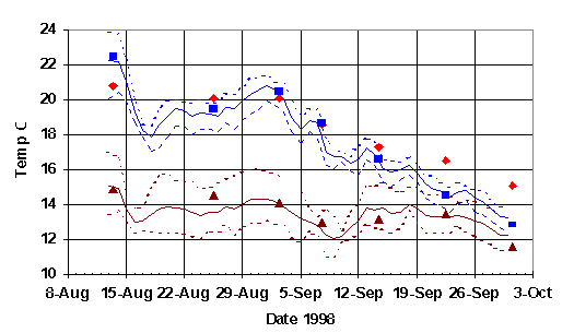
C12 Glendale, Tsolum and Quinsam River Temperature Data 1998
Legend
SECTION 6, APPENDIX D.
Copper Data
Figure D1. Tsolum River
Watershed Copper Sampling Sites
Table D1.
Comparison of copper loadings recorded at
Branch126 between 1986-1998.
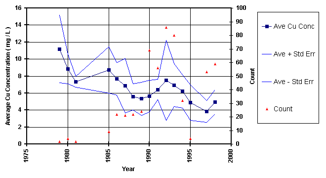
| Month - Year | Total Flow (dam3) | Average Copper Concentration (mg/L) | Monthly Copper Loadings (kg) |
| May-86 | 150.5 | 7.55 | 1076 |
| Jun-86 | 108.6 | 4.87 | 503 |
| Apr-87 | 34.5 | 6.25 | 212 |
| May-87 | 148.8 | 4.7 | 789 |
| Jun-87 | 146.3 | 3.26 | 511 |
| Apr-88 | 65.5 | 5.34 | 393 |
| May-88 | 139.4 | 5.89 | 885 |
| Jun-88 | 115.2 | 4.37 | 513 |
| Apr-89 | 64.8 | 5.01 | 347 |
| May-89 | 141.9 | 5.38 | 835 |
| Jun-89 | 87.8 | 3.6 | 355 |
| Apr-98 | 27 | 3.5 | 98.9 |
| May-98 | 141 | 2.79 | 403.7 |
| Jun-98 | 143 | 1.41 | 198.6 |
Figure D2 Average copper concentration at
Pyrrhotite Creek, Branch 126.
Click on graph for full size
|
Water Monitoring
Temperature
Monitoring
Copper Sampling
Bioassay Program
Siltwatch
References
Temperature Probe Locations
Photos of temperature loggers
Temperature Data
Copper Data
![]()
![]()