|
|
|
Click on photo to see the view today |
|
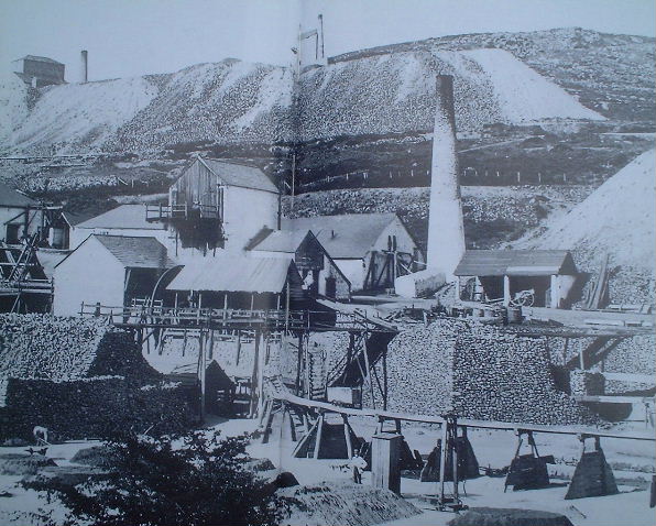
The view shows the centre of operations of the South Caradon mine at its peak of development. It looks Eastwards across the Seaton Valley towards the slopes of Caradon Hill. Central to the view is south Caradon stamps to the left of which lie many of the subsidiary buildings of the mine. Two of the mine shafts lie in the background whilst the foreground is occupied by the Liskeard and Caradon railway siding with piles ore waiting shipment down to Looe harbour.
Michael messenger states that the photograph was taken sometime prior to the mines final enclosure in 1885. The existence of Pearces shaft engine house, built in 1870 ,confirms that the photograph was taken late in the mines life. Early in the mines history this area could have looked considerably different because of the improvements in facilities that occurred here between 1862 and 1864.
Historical background
This is a view of an industry
in a decline, the peak activity of Cornish Copper mining having passed
by the end of the 1870s. The collapse of Cornish mining in the face of
plummeting copper prices was to lead to the mass exodus from Cornwall in
the 1880s of up to a quarter of the working population.
And yet it is also a picture
of Mine in full production with the output of South Caradon becoming
the largest in Cornwall during the 1870s. Copper ore
production averaged over 5800 Tons a year between 1870 and 1882 and
even in the last three years up to 1885 it was still averaging above 3500
tons. This contradiction between success and failure is accounted for a
by a plummeting price of Copper , a fall caused by the growth of new sources
around the world. As the price fell the cost of pumping and development
could no longer be met and this famous mine was forced to close with copper
still available beneath the ground.
An interpretation
The cluttered nature of
a the processing area of a mine can clearly be seen. Buildings, tramways,
leats, machinery, ore and waste compete for the valuable space in
the bottom of the Seaton Valley. Terracing and walled revetments
add a three dimensional complexity to the layout.
Despite the crowding of
structures the scene gives an impression of an well maintained and organised
site. Even the wooden roofs are in a good state of repair , a rarity in
Cornish mines. In addition to its use in roofing ,wood can be seen to be
used to form tramways, stairs, launders and walkways.
An indication of the amount
of extent of the rock removed from underground can be obtained from the
amount of waste rock visible. Caradon hillside behind the buildings
is almost obscured by burrows from Sump and Pearces shaft, whilst the
tips intruding from the right threaten to engulf the cart shed.
Within this complex of buildings
only two workers can be seen, one shoveling ore and another watching the
photographer. This is on a mine that employed over 420 people in 1880,
177 of whom worked above surface.
 |
Caradon
& Looe
The Canal, Railways and Mines by Michael Messenger The definitive history of the Liskeard & Looe Union Canal, the Liskeard & Caradon Railway and the Liskeard & Looe Railway was first published in 1978 and has been scarce and sought after for some years. This new edition has been fully revised and benefits from additional research and many new illustrations. ISBN 0 906294 46 0. 168 pages, 222 illustrations. Hard back with full colour dustwrapper For an online supplier of this book see Willlow books For a supplier at Minions see Hurlers halt |
|
|
|
|