
A view of
South Caradon Mine
The Mid Seaton Valley
|
A view of South Caradon Mine |
The Mid Seaton Valley
|
Home Page The walk Maps History Views Information Sources
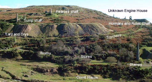
| A view taken on a crisp Autumn morning showing area that once formed South Caradon's processing and administrative centre. The internal network of tramways brought the ore from all the shafts to the head of stamps from where it was distributed to the sheds on the dressing floors. A variety of support buildings lay in this area including the important two storey count house, the mine's headquarters. Some of the later workings of the mine can be seen on the horizon, Holman's and Rule's shaft lying on the southern slopes of Caradon Hill. Beyond these, out of sight the mine extends eastwards to Kittow's shaft. | ||||||||||||||
|
 |
|||||||||||||
|
||||||||||||||
|
|