 A View of South Caradon Mine |
South Caradon Mine Main Lode |
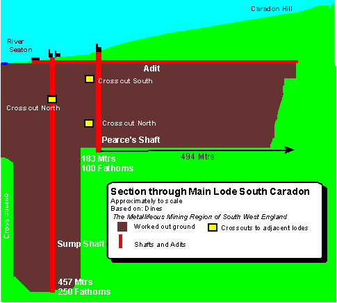 Main lode was the first
lode that the Clymo's found when they
dug eastwards from the Seaton Valley. Sump Shaft was the earliest shaft to
be dug on the mine, and at 250
fathoms was the deepest in the Caradon area. The adit
opened out onto the dressing floors under the yard,
draining the water raised from Sump and Pearce's shafts into the River
Seaton.
Main lode was the first
lode that the Clymo's found when they
dug eastwards from the Seaton Valley. Sump Shaft was the earliest shaft to
be dug on the mine, and at 250
fathoms was the deepest in the Caradon area. The adit
opened out onto the dressing floors under the yard,
draining the water raised from Sump and Pearce's shafts into the River
Seaton.
The lode runs roughly east to west and underlies 40 degrees to the north. Pearce's shaft is sunk at this angle (on the underlie) but Sump shaft is sunk vertically down to 20 fathoms (37 metres) where it cuts the lode.
Cross-cuts run north and south to develop other lodes. Dines states(pp601) that the lode splits 270 fathoms east of Pearce's shaft but this is not shown on the 1863 map. On the map though, a second lode called Dowding's lode is shown close to the south.
This diagram gives an idea of the extent of the underground workings beneath the ground at South Caradon Mine. It shows the approximate area of ground that has been worked for ore on the main lode from Sump and Pearce's Shaft, and it is based on the information contained in Dines. The workings extend to the sett boundary in the west, under the Seaton River. To the east the workings extend almost 1/2 Km from Pearce's shaft. and they go downwards almost the same amount to a depth of 457mtrs.
| For More Information |
| View of area with the lodes shown |
| View of the area |
| Sump pumping engine |
| Sump winding engine |
| Pearce's pumping engine |
| Main adit |
| Other Maps |
| Footpath |
| South Caradon Mine |
| Lode map (1863) |
| Sump Shaft |
| Valley floor |
|
On many mine sites in Cornwall dangers may still exist, many hidden. This web site is published as a resource to those using public rights of way. |
|||
|