Home Page | Club Details | Calendar of Walks | Picture Gallery |
Wales 2000
| The Ecrins
| Cooley Walk | News, Letter & Links | Notice Board
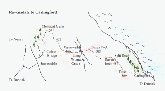
Ravensdale to Carlingford (1:50,000 Sheet 29)
Starting at Ravensdale one can make a fine day's walking over the Cooley Hills. The finish is the beautiful old Norman town of Carlingford.
What the hills lack in height (You are never more than 600m.), they compensate for in views, variety of terrains and history. Follow in the steps of Cuchulain!
Ravensdale uis just off the Dundalk/Befast road, 6km North of Dundalk. Park at Ravebsdale Bridge, close to the Post Office, and take the road NE to Anaverna/Carrabane. On the last bend on the road to Carrabane, turn left over a small stream and follow the track to Cadger's Bridge. Over the bridge follow the walls out onto the open countryside. Once can take a track to the summit of Clermont Cairn or take a course to The Ben Rock and then to Clermont Cairn 510m.
You are now in the area where the annual Puc Fada Competition is held. This is a competition where the winner is
the player who covers the course with the least number of hurley 'pucs'. The yellow stones mark the route... some
of the archaeology under The Ben Rock is somewhat modern!
There is a track from Clermont to Carnamaddy (466m.), the grave of the hound!
Take a bearing to The Long Woman's Grave. The Long Woman was a Spanish lady, called Cathleen, who dropped dead on this spot. A local O'Hanlon persuaded her to marry him, by promising her that everything she could see from a mountain in the area would be hers when they married. The sight must have been fatal!
The walk from the Long Woman's Grave to Carlingford is a beautiful ridge walk, which gradually rises to the summit overlooking Carlingford. On a good day it is possible to see as far as Hungry Hill overlooking Belfast, the Sperrin Mountains and the Wicklow Mountains. Local views incluse the Mournes, Gullion and the Newry Canal.
The easiest way into Carlingford is to descend along the woods to the north of the town.
Our favourite "watering hole" after this walk is PJ O'Hare's on the corner of the square.
Distance 15km. Walking Time 5/6 hours. Highest point 589m. A moderate walk.
Home Page | Club Details | Calendar of Walks | Picture Gallery |
Wales 2000 | The Ecrins | Cooley Walk | News, Letter & Links | Notice Board