Mt. Kidd South - Kananaskis Country
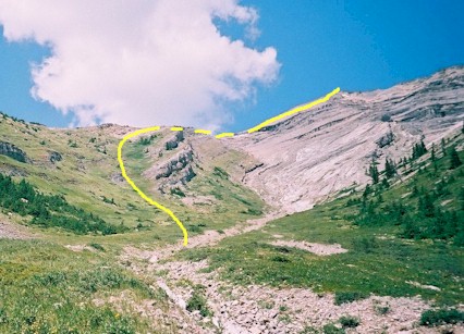
View of upper gully once you leave Galatea trail and go though
trees and up the steep lower part of gully

Once you reach the ridge top it's a 5 minute traverse to the
summit cairn.

Here's the happy crowd at the summit in 30C weather. Left
to right, Allan, Darcy, Blake, Michael, and Maja.
Mt. Kidd South
Scramble: Class 1 – Steep Hiking
Altitude: 2,895m (9,496 ft)
Ascent Time: 3 1/2 – 4 1/2 Hours
Elevation Gain: 1,290m (4,231 ft)
Best Season to Scramble: June to September
Highlights
This scramble has an hour long hike along Galatea trail before
you even start heading up hill. From the Galatea trail it’s straight up a steep slope
all the way. Sounds like fun, eh! I would recommend a cooler day for this one. I went when
it hit 30C even on the summit. It was good I had 3 of those ˝ litre steel vacuum bottles
full of ice water as well as a couple of litres of regular H2O. Nevertheless the summit
views were very nice and gave you that "way up there" feeling.
Getting There
Head west out of Calgary on the TransCanada highway # 1 for
79km (49.4 miles) and take the Kananaskis Country Highway 40 turnoff and head south. If
your base is Banff head east on the TransCanada for 52 km (32.5 miles) and turn south on
route as above. Drive south for 32.7 km (20.4 miles) to the Galatea Creek parking lot.
Parking lot is a right hand turn off the highway.
Route Description
From the parking lot follow the trail down across the big
bridge until you come to a T-intersection. Head left as if for Lillian Lake. You will
cross 6 bridges (this includes the big bridge across the Kananaskis river) and about a
minute before the 7th bridge you will enter a flat area of large shady trees.
This takes around 1 hour to get to this spot. Watch for a obscure trail with some deadfall
at the start of it heading to the right. There might be a cairn by the side of the Galatea
trail and an orange ribbon on one of the trees. Sometimes the cairn gets knocked over.
Anyways, there is a long distance between the 6th and 7th bridge and
you can see the big gully up to your right as you approach the 7th bridge. Once
the gully opens up, head up steep grassy slopes to your left to access the final slope to
the ridge top. From the ridge top you head east traversing along the right (south),
it’s only a few minutes to the summit cairn.
Please note your ascent route by
looking back frequently and descend the same way. There is still some
confusion on the proper ascent gullies when leaving the Galatea trail. I
hope to do a little more research and nail down the gully issue. For now if
you leave the Galatea trail at the proper spot you should arrive at the view
of the first photo and the route should be straight forward from here. If
you find yourself in increasingly difficult terrain you would be wise to not
continue as you may be off route.
