Opal Ridge S - Kananaskis Country
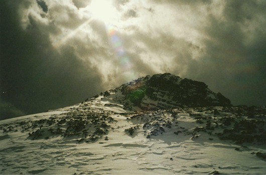
Wanted to try my new Alpina Mount boots in late October and caught a
nice picture on the last section of ridge to the summit! Boots were great for being
crampon compatible. Only one small blister!
Opal Ridge South
Scramble: Class 1 – Steep Hiking
Altitude: 2,590m (8,495 ft)
Ascent Time: 2 -3 Hours
Elevation Gain: approx. 885m (2,903 ft)
Best Season to Scramble: May to September
Highlights
This scramble is a really pleasant one with great views of the
Kananaskis corridor. It has a nice little ridge walk to the southern high point. It can be
a little windy especially if the forecast is for a weather system coming from the
southwest.
Getting There
Head west out of Calgary on the TransCanada highway # 1 for
79km (49.4 miles) and take the Kananaskis Country Highway 40 turnoff and head south. If
your base is Banff head east on the TransCanada for 52 km (32.5 miles) and turn south on
route as above. Drive south for 40.7 km (25.4 miles) to the Fortress Mountain Shell gas
station. This necessitates a left-hand turn off the highway. Park at the north end of the
lot. The owners do not mind scramblers using this area.
Route Description
At the NE end of the parking lot there is a small stream
flowing into a culvert. Looking up this slope there is a power cut-line, which heads north
and south. Hike up the right side of the stream till there is an obvious crossover spot to
a footpath on the left. This footpath takes you up to the cut-line, from there you head
north along the cut-line. This would be a left-hand turn when you reach the cut-line. Walk
along the cut-line for a few minutes looking for a trail that heads off to the right.
Don’t take the first trail that looks like an old road as this takes you up the right
hand slope and will necessitate bushwhacking across a steep gully to get on the correct
left-hand slope. Go a bit further where the cut-line dips down and you cross a small
streambed and will see the correct trail just beyond. From here it is straightforward
steep hiking. There is an obvious trail most of the way but it occasionally fades out. As
long as you keep near the center of the slope you will meet up with the trail sooner or
later.
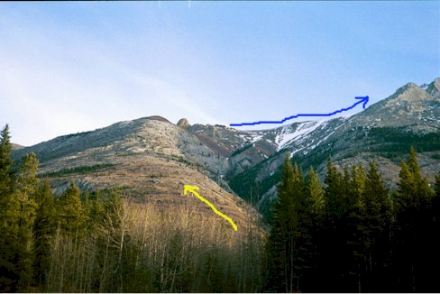
Once you surmount the hump about ľ of the way up there is a short
relatively flat part to the final slope. From this hump go straight ahead up this final
short steep slope between two rock outcrops. Exiting from between the rock outcrops you
will see the ridge walk trail to your right (south). From here it is a nice ridge walk
keeping left where necessary.
Looking south the high point is 15 to 20 minutes away.