|
Dog Friendly Hikes near Baltimore < 1 hr from Balto.
|
Undeveloped Areas basically mean any section of the park
that doesn't have picnic areas, ball fields, or any other
maintained buildings. This means that if you have a dog you
won't be entering the park through any of the main gates, but
at trailheads that access the park.
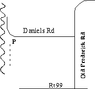
The park publishes A Guide to Your Pet in Patapsco Valley State Park, a brochure that discusses the park rules for pets and shows five of these undeveloped areas. Most of the trails indicated are unmaintained and are used by hikers, horseback riders and mountain bikers. Here are the three trails that I like best. The trail name is linked to a map showing how to get to the trailheads: Daniels Area- This area of the park was the sight of an old town along that Patapsco that was basically destroyed by flooding caused by hurricane Agnes in the early 70's. Trails are available on both sides of the Patapsco, but there is no easy access from one side of the river to the other. The main trails are flat and wide, as the main trail used to be a road. There are also some spur trails as well. (5+ miles each way)
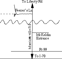
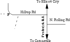
Feezer's Lane- This is near the McKeldin Area. It can be reached by taking Marriottsville Rd and turning on to Feezer's Lane, just north of the McKeldin area entrance. This is a gravel road. The trail head and a parking area are located a few hundred feet from Marriottsville Rd. The trail travels along the river to the foot of Liberty Dam. There are a number of spur trails, including a large one that travels away from the river and eventually climbs up to Liberty Reservior. There are even more hiking opportunities around the reservior. (~2 miles) Hilltop Road- This is my favorite of the dog trails I've explored in Patapsco. It's part of the Hilton Area of Patapsco. The trail head is accessed off of Hill Top Rd. This is in Catonsville, off of Frederick Rd, just west of the Rolling Rd. intersection. There is a trail head at the parking lot which goes down to the river. This is primarily used by fishermen for quick access to the Patapsco. Just before the parking lot is another trail head. This is the Buzzard's Rock trail (yellow blazes). At the first fork, stay right. The trail will cross over an open field and then back into the woods eventually coming to Buzzards Rock, which overlooks the Patapsco. The trail turns left and heads down (rather steeply at times) into the river valley. It will eventually intersect with the Saw Mill Run trail (red blazes). At this point you can either take the trail left (before crossing the stream) and follow it upstream, or you can cross the stream and follow it upstream on that side (you'll have to cross back eventually). Follow the red blazed trail up Mill Run. It will eventually intersect again with the Buzzards Rock trail on your left. Follow the Buzzards Rock trail up out of the valley and back up to the trail head. (~3 miles) You can also follow the Mill Run trail Downstream, underneath the railroad tracks and head down to the Patapsco. There is a trail along the river that you can follow. Downstream it eventually comes to the swinging bridge which is the beginning of a developed area
| ||||||||||||
Last update - 7/1/97
Maintained by Jeff Bolognese