Home
| Skerries
| Northern
Ireland | Northern
Ireland | Donegal
| Donegal
| Donegal
| Westport
| Clifden
| Galway
| Bunratty
| Kenmare
| Kenmare
| Kenmare
| Goleen
| Cahir
| Glendalough
| Dublin
| Map | B&Bs
| Links
Day 3 - Saturday, May 11, 2002
We had a great breakfast overlooking the sea at 8:15 AM.
Later we chatted with Mary, the owner, about the reputation that continues to
haunt Northern Ireland. As she put it, if you're raised on hate, you're going spread it wherever you go. It looked like we were in for a day of rain as a fine
mist fell while we were talking. By the time we were in the car though, the
skies had cleared and we were off to a beautiful start. We decided to do the
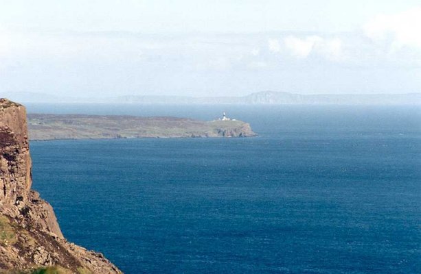
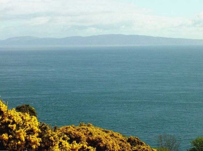
Torr Road again, this time with clear skies. Mary had suggested that on a clear
day you can make out Scotland in the distance.
spread it wherever you go. It looked like we were in for a day of rain as a fine
mist fell while we were talking. By the time we were in the car though, the
skies had cleared and we were off to a beautiful start. We decided to do the
Torr Road again, this time with clear skies. Mary had suggested that on a clear
day you can make out Scotland in the distance. 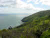 That
day, the Mull of Kintyre seemed close enough to touch. We couldn't believe that
we hadn't seen it the night before. The views were every bit as wonderful as the
night before, but this time the visibility looked to be about 50 miles or more.
I swear that I could just make out the peaks on the Isle of Skye in the
distance, but Felicity said I was crazy. This time, as we approached the end of
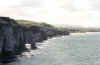
Torr Road, we turned off and took a tiny road out to Murlough Bay. We never made
it down to the bay, but the scenery from the cliff's edge was great. There were,
of course, sheep everywhere. Rathlin Island seemed so close, I thought it was
the mainland.
That
day, the Mull of Kintyre seemed close enough to touch. We couldn't believe that
we hadn't seen it the night before. The views were every bit as wonderful as the
night before, but this time the visibility looked to be about 50 miles or more.
I swear that I could just make out the peaks on the Isle of Skye in the
distance, but Felicity said I was crazy. This time, as we approached the end of
Torr Road, we turned off and took a tiny road out to Murlough Bay. We never made
it down to the bay, but the scenery from the cliff's edge was great. There were,
of course, sheep everywhere. Rathlin Island seemed so close, I thought it was
the mainland.
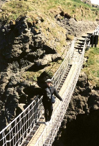
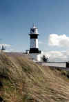
This was going to be a busy day, so we headed off to
Carrick-a-Rede. We made it to the parking lot and it was almost empty. As with
virtually everyday on this trip, it was windy, but not too windy to close the
bridge. As I remember, it is about a 15-20 minute walk to the bridge. The walk
gives you views of chalk white cliffs and Rathlin Island in the distance. You
don't see the bridge until you are just above it. We both crossed and took
pictures of each other, but there were people waiting behind us, so we didn't
linger on the bridge. Even with the wind, It wasn't particularly scary. The
Island itself is a beautiful location. You pass the steps down to the "fishing
port" just after you cross the bridge and a very short walk takes you to
the top of the island. Mind you, this is a very small island and you can go from
edge to edge in about a minute. Once again, you will have views of Rathlin
Island and on a clear day, Scotland in the distance.
As I remember, it is about a 15-20 minute walk to the bridge. The walk
gives you views of chalk white cliffs and Rathlin Island in the distance. You
don't see the bridge until you are just above it. We both crossed and took
pictures of each other, but there were people waiting behind us, so we didn't
linger on the bridge. Even with the wind, It wasn't particularly scary. The
Island itself is a beautiful location. You pass the steps down to the "fishing
port" just after you cross the bridge and a very short walk takes you to
the top of the island. Mind you, this is a very small island and you can go from
edge to edge in about a minute. Once again, you will have views of Rathlin
Island and on a clear day, Scotland in the distance.
As we were leaving the Island, we discovered why it is that
we are not tour bus types. As we got to the 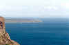 bridge, a bus load of people had
just arrived to cross from the other direction. The serenity of the area was
gone. A row of easily 50 people of all ages stood waiting on the stairs and up
and around the corner to make the perilous crossing. Just as a person would get
close to our side, another one would begin the trek across the bridge. This is a
one way path and it took quite a while to convince them that we wanted to cross.
It probably took close to an hour to get them all across. That's when it
occurred to us than when you're with a tour, everywhere you travel is crowded.
bridge, a bus load of people had
just arrived to cross from the other direction. The serenity of the area was
gone. A row of easily 50 people of all ages stood waiting on the stairs and up
and around the corner to make the perilous crossing. Just as a person would get
close to our side, another one would begin the trek across the bridge. This is a
one way path and it took quite a while to convince them that we wanted to cross.
It probably took close to an hour to get them all across. That's when it
occurred to us than when you're with a tour, everywhere you travel is crowded.
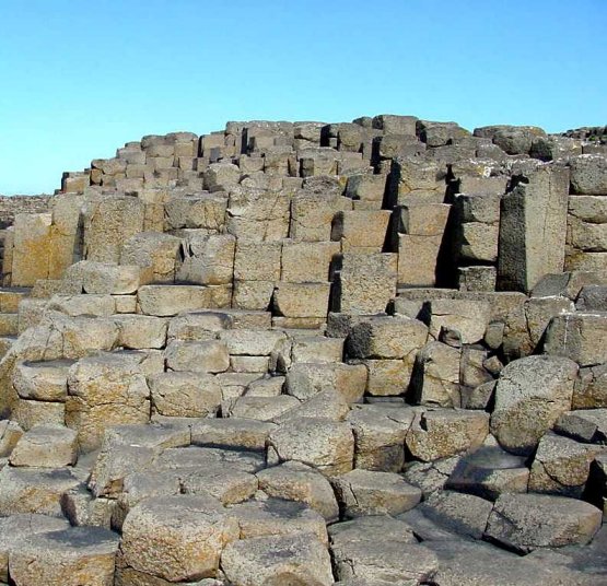
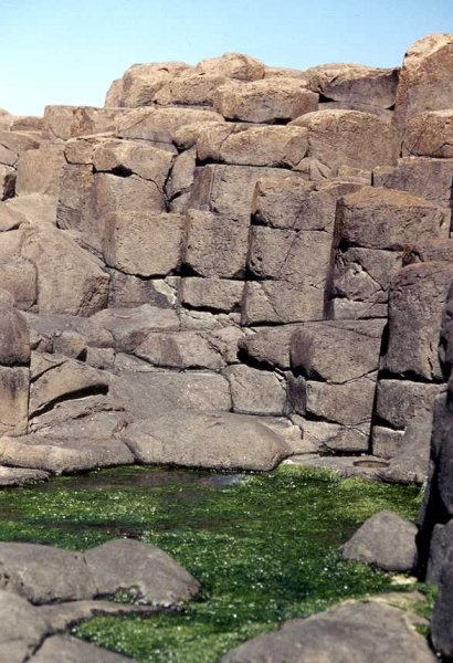
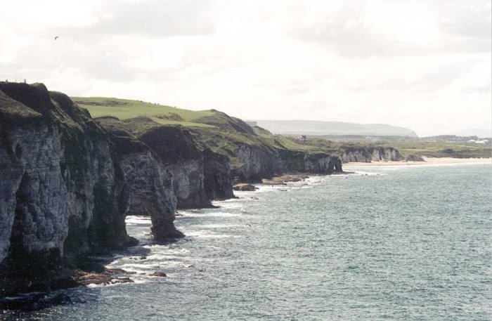
We headed next to Giants Causeway. This section, from
Carrick-a-Rede to Dunluce Castle, was the only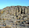
 area
of Northern Ireland where we experienced crowds. We didn't let it bother us too
much. When we got to the Causeway we decided to be lazy and take the free bus to
the famous basalt columns. I was pretty thankful for this. The columns are quite
an amazing geological formation. Many people had brought picnic lunches to eat
while sitting amongst the columns. It was a nice place for a snack but it
sort of detracted from the natural beauty. I could live with it though. If you
feel inclined, there is a walk that will take you along the Causeway Coast that
would make for a nice long day of hiking. We chose not to do this. In the end, I
found Giants Causeway to be more interesting than spectacular, but that may have
had something to do with having driven the Torr Road.
area
of Northern Ireland where we experienced crowds. We didn't let it bother us too
much. When we got to the Causeway we decided to be lazy and take the free bus to
the famous basalt columns. I was pretty thankful for this. The columns are quite
an amazing geological formation. Many people had brought picnic lunches to eat
while sitting amongst the columns. It was a nice place for a snack but it
sort of detracted from the natural beauty. I could live with it though. If you
feel inclined, there is a walk that will take you along the Causeway Coast that
would make for a nice long day of hiking. We chose not to do this. In the end, I
found Giants Causeway to be more interesting than spectacular, but that may have
had something to do with having driven the Torr Road.
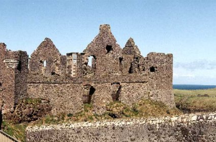
Dunluce
Castle was next. Another short drive and we were there. The castle is in
ruins, but it's perch on the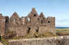
 cliff's edge makes for a memorable site. The cliff's edge is a part of it's most
often told history, that of the kitchen and it's staff falling into the sea on a
stormy evening in 1639. From the area near where the kitchen used to be, you can
look west along the coast and see the "wishing arch". Apparently, if
you made a wish while viewing the giants head through the arch, your wish would
be granted. That is apparently not an easy position to get to.
cliff's edge makes for a memorable site. The cliff's edge is a part of it's most
often told history, that of the kitchen and it's staff falling into the sea on a
stormy evening in 1639. From the area near where the kitchen used to be, you can
look west along the coast and see the "wishing arch". Apparently, if
you made a wish while viewing the giants head through the arch, your wish would
be granted. That is apparently not an easy position to get to.
 We decided to continue on and spend the night on the
Inishowen Peninsula. As it turned out, it was a pretty easy drive. We drove up
the Coast through Moville to Dunagree Point and then came back and settled on
the Seawater View B&B in Redcastle. It was a newly
We decided to continue on and spend the night on the
Inishowen Peninsula. As it turned out, it was a pretty easy drive. We drove up
the Coast through Moville to Dunagree Point and then came back and settled on
the Seawater View B&B in Redcastle. It was a newly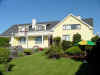 redecorated place and had
a beautiful view of Lough Foyle, which is essentially the bay which leads out to
the North Atlantic. We had dinner in Moville at "The Town Clock". It
was originally an old market building that had been converted into a restaurant.
It was a beautiful place and the food was excellent. The Irish have a different
idea of "spicy" My stuffed chicken breast in a spicy red pepper sauce
was great, but not very spicy. We had banofee for dessert. This is an Irish
specialty I presume....a toffee base with bananas on top and lots of fruit on
the side. It was fantastic.
redecorated place and had
a beautiful view of Lough Foyle, which is essentially the bay which leads out to
the North Atlantic. We had dinner in Moville at "The Town Clock". It
was originally an old market building that had been converted into a restaurant.
It was a beautiful place and the food was excellent. The Irish have a different
idea of "spicy" My stuffed chicken breast in a spicy red pepper sauce
was great, but not very spicy. We had banofee for dessert. This is an Irish
specialty I presume....a toffee base with bananas on top and lots of fruit on
the side. It was fantastic.
We followed our dinner with an evening drive that took us
out to Kinnagoe Bay. Then, struggling to keep our eyes open we returned to our
B&B to get some rest after a VERY long day.
More
Photos
Home
| Skerries
| Northern
Ireland | Northern
Ireland | Donegal
| Donegal
| Donegal
| Westport
| Clifden
| Galway
| Bunratty
| Kenmare
| Kenmare
| Kenmare
| Goleen
| Cahir
| Glendalough
| Dublin
| Map | B&Bs
| Links
[ Back ] [ Next ]
 spread it wherever you go. It looked like we were in for a day of rain as a fine
mist fell while we were talking. By the time we were in the car though, the
skies had cleared and we were off to a beautiful start. We decided to do the
Torr Road again, this time with clear skies. Mary had suggested that on a clear
day you can make out Scotland in the distance.
spread it wherever you go. It looked like we were in for a day of rain as a fine
mist fell while we were talking. By the time we were in the car though, the
skies had cleared and we were off to a beautiful start. We decided to do the
Torr Road again, this time with clear skies. Mary had suggested that on a clear
day you can make out Scotland in the distance. 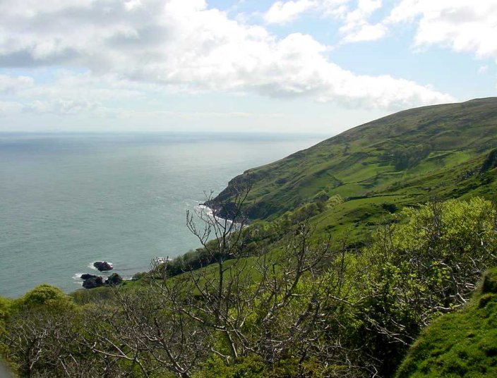 That
day, the Mull of Kintyre seemed close enough to touch. We couldn't believe that
we hadn't seen it the night before. The views were every bit as wonderful as the
night before, but this time the visibility looked to be about 50 miles or more.
I swear that I could just make out the peaks on the Isle of Skye in the
distance, but Felicity said I was crazy. This time, as we approached the end of
Torr Road, we turned off and took a tiny road out to Murlough Bay. We never made
it down to the bay, but the scenery from the cliff's edge was great. There were,
of course, sheep everywhere. Rathlin Island seemed so close, I thought it was
the mainland.
That
day, the Mull of Kintyre seemed close enough to touch. We couldn't believe that
we hadn't seen it the night before. The views were every bit as wonderful as the
night before, but this time the visibility looked to be about 50 miles or more.
I swear that I could just make out the peaks on the Isle of Skye in the
distance, but Felicity said I was crazy. This time, as we approached the end of
Torr Road, we turned off and took a tiny road out to Murlough Bay. We never made
it down to the bay, but the scenery from the cliff's edge was great. There were,
of course, sheep everywhere. Rathlin Island seemed so close, I thought it was
the mainland.