Big Sister - Spray Lakes Road
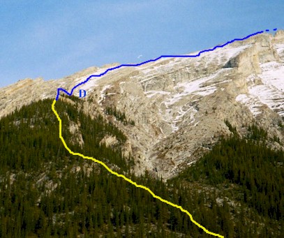
D - Down climb just beyond tree
line

Photo of down climb courtesy of
Granticulous

The big slope looking down from the col. Michael Teekens and Al
Strandberg plodding their way up. You can just make out the parking lot below.
Big Sister
Scramble: Class 2 – Steep Slab Hiking, Use of hands, Couple of
short 5 to 7 meter down-climbs, Some exposure, Some route finding
Altitude: 2,936m (9,630 ft)
Elevation Gain: 1,200m (3,936 ft)
Ascent Time: 3 – 4 ˝ Hours
Best Season to Scramble: July – September
Best Conditions to Scramble: Dry and Snow Free Conditions, Would not
recommend this scramble if conditions are not perfect
Highlights
This scramble offers a little bit of everything, short
approach, steep slabby sections, scrambling on all fours, down-climbs looking through your
feet, route finding, great views and a sense of accomplishment when completed. Highly
recommended when conditions are dry and you’ve done some easier scrambles.
Getting There
Head west out of Calgary on the TransCanada highway # 1 to
Canmore 106km (66.2 miles). From the Bow River bridge in Canmore drive 17.3 km (10.8
miles) up the Spray Lakes road to the Big Sister gravel parking area. The road from the
Bow River bridge takes you past the Canmore Nordic Centre and onto the Spray Lakes road
(packed gravel). The Big Sister parking area is a left-hand turn just as you hit the Spray
Lakes dam. From the parking area you will see directly ahead the imposing gully system of
the southwest side of Big Sister. If your base is Banff head east on the TransCanada for
26km (16.2 miles) to Canmore and follow route as above.
Route Description
From the parking lot head up towards the gully system crossing
the creek bed to the left and follow the ascent trail up the left-hand side of the gully
system. The trail rises steeply through the trees until you reach open slabs. A few
minutes further up there are two possible spots to down-climb onto the face. The second
spot a little further up is the easier one although when I first climbed this I
down-climbed the harder one. Didn’t see the easier spot till on the way back down.
Continue up the face until you reach the top of the ridge before the route curves over to
the right. From here follow along steep slabby terrain bypassing to the right or going
over a 5 ft high bump on the ridge. Be careful here especially if the route is not dry.
Continue up steep terrain until you reach a down-climb of 5m (17ft). The down-climb leads
you to the left of the summit ridge pinnacles. Keep close to the wall of the pinnacles and
be careful here. Once past the pinnacles the final steps to the summit are a bit less
demanding.
