Mt. Yamnuska - Canmore Bow Valley
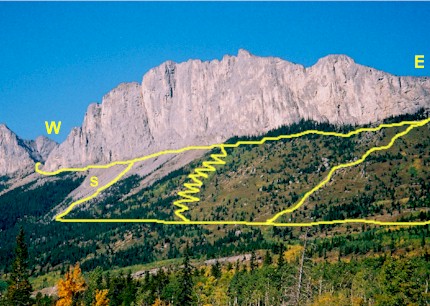
Trails on the front slopes of Yamnuska, trailhead is a bit
further to the east of picture
W - West E- East
S - Awesome scree run
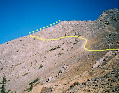
Backside of Yamnuska from the West
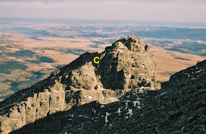
Scrambling from the East side, here is looking back at the crux
downclimb of 5m, not far from the summit
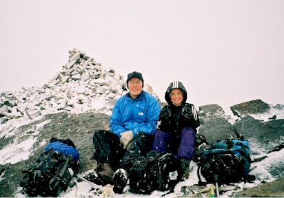
Victoria and Al on the summit about to enjoy a hot cup of java!
Mt. Yamnuska – Canmore Bow Valley
Scramble: From West Side Class 1 – Steep Hiking
From East Side Class 2 – Steep Hiking, Use of Hands on
difficult downclimb of 5 metres
Altitude: 2,240m (7,347 ft)
Elevation Gain: 900m (2,952 ft)
Ascent Time: 2 – 3 Hours
Best Season to Scramble: July to October
Highlights
This scramble because of its easterly location often escapes
much of the snowy weather that Banff and Lake Louise get. It’s the first mountain on
your right as you come into the Rockies from Calgary on the Trans Canada highway. The
scree runs are just the best! It can be scrambled much earlier than July, but if you do,
you must be aware of "tick" season. May and June are the months where
"ticks" are most active so you must learn about them and take proper
precautions.
Getting There
Head west out of Calgary on the TransCanada highway # 1 to the
Seebe turnoff (approx 63.5km from the Canada Olympic Park intersection to the Seebe
turnoff), head north for 4.2 km to the old 1A, you’ll be looking right at the steep
southern face of Yamnuska. At the intersection of the old 1A hightway head right
(you’ll be travelling east) for approx 2.0 km and then just past a corner on the 1A
take a left turn and follow a gravel road to the newly developed parking lot.
Route Description
From the gravel parking spot take either the road or the trail
from the information board for one minute until you come to the trailhead where there is a
climber sign-in box. From here follow the broad trail for about 15 minutes up a steep
section to a sign post. The sign post has an arrow for horses to head right but go
straight on through. After another 10 minutes up the trail you will see the steep trail to
your right for those who wish to go to the East side and do the traverse from East to
West. Another 5 minutes past this point is another trail to the right which switchbacks up
to the middle face of Yamnuska, then traverses along the face to the West side.
East to West Traverse – follow the first steep trail mentioned up
to the East shoulder of Yamnuska. Once you reach the East shoulder a panorama of the North
side of the mountain unfolds, a good spot to catch your breath and have a snack. The
proper trail then drops down a bit to go around the rock buttresses and from here you can
see the backside of the mountain proper. There is more than one trail but the best way is
to go higher as soon as possible and traverse along the upper part of the mountain. Just a
short distance from the summit you encounter the crux which is a short steep downclimb of
5 metres.
West Side – Taking the second right hand trail which switch backs
up to the centre of the face then has a pleasant traverse to the West shoulder of the
mountain. Once you are on the backside of the mountain it is steep hiking to the top.
Either way, it’s better to come back the West side and take one of
the longest scree runs in the Rockies as noted on the pictures. Enjoy!
