East End of Rundle - Canmore/Spray Lakes Road
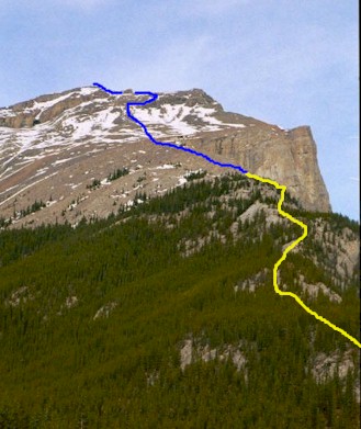
Basic route up the ridge
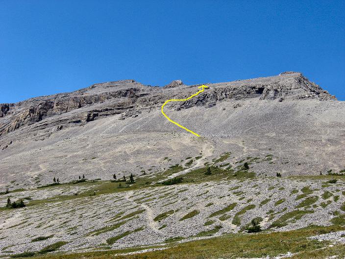
Closer look at upper slope
East End of Rundle
Scramble: Class 1 – Steep Hiking, short section use of hands on
slope to skirt around last cliff band
Altitude: 2,590m (8,495 ft)
Elevation Gain: 900m (2,952 ft)
Ascent Time: 2 – 3 Hours
Best Season to Scramble: May to October, Ridge can be windy
Highlights
This scramble offers nice views and is great early season
training for bigger scrambles later on. From its summit you can see the majestic Mt
Assiniboine, something that you do miss from the summit of Ha Ling Peak which is 600 ft
shorter.
Getting There
Head west out of Calgary on the TransCanada highway # 1 to
Canmore 106km (66.2 miles). From the Bow River Bridge in Canmore drive 8.6 km (5.4 miles)
up the Spray Lakes road to the Goat Creek parking lot. The road from the Bow River bridge
takes you up past the Canmore Nordic Centre and onto the Spray Lakes road (packed gravel).
Just past the Nordic Centre the road turns to dusty gravel and you head uphill for a few
kilometers. Go slow so the odd mountain biker climbing this road has less dust to eat. It
levels off at the gap between Ha Ling Peak and the East End of Rundle then goes down a
short hill then hang a right into the parking lot. If your base is Banff head east on the
TransCanada for 26km (16.2 miles) to Canmore and follow route as above.
Route Description
From the parking lot head left back up the road you came until
its levels off. You should find the trail on the left between the Bow/Crow Forest sign and
a second set of power poles. Follow this to gain the ridge. From here the trail takes you
up the ridge to tree line. The last section before tree line takes you on the right side
of the ridge with nice views of Canmore, the canal and Ha Ling Peak. Once you reach tree
line head left following the scree trail up towards a patch of scrubby trees. Above this
the slope widens and you should head up towards the center of the slope to the rock band.
There is a short steep section of loose rock up to the face of the final slope. Gain the
face and traverse right, up around onto the final short slope. Continue zig zagging up to
the high point. You are almost done. From here it’s a short ridge walk north west
(left) to the obvious high point.
If you have a clear day Mt Assiniboine can be seen to the southwest.