Fortress Mtn - Spray Lakes Road
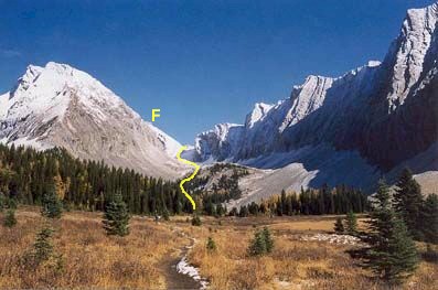
The view up the valley is foreshortened in this picture.
It's about a one km hike past the lake to the Fortress col.
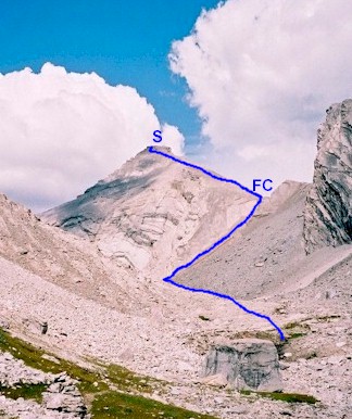
S - summit FC - Fortress Col

Here's the col, it's a lot steeper than it looks here.

A view from the col, Chester Lake and the valley you come up
is to the right.
Fortress Mountain or The Fortress
Scramble: Class 1 – Steep Hiking, Some Hands-on at Summit block
Altitude: 3,000m (9,840 ft)
Elevation Gain: 1,100m (3,608 ft)
Ascent Time: 3 – 4 Hours
Best Season to Scramble: June to September
Highlights
This scramble starts with hiking to beautiful Chester Lake
located in a high alpine meadow, then up a valley behind the lake and offers really nice
views Mt Kidd, Mt. Galatea, and even Mt. Assiniboine on the distant horizon. This is one I
would do more than once.
Getting There
Head west out of Calgary on the TransCanada highway # 1 for
79km (49.4 miles) and take the Kananaskis Country highway # 40 turnoff and head south.
Continue south and turn right into Peter Lougheed Provincial Park which is 49km (30.6
miles) south of the TransCanada. From this turnoff drive 2 km (1.25 miles) and turn right
on Spray Lakes road driving around another 20km (12.5 miles) north until you reach the
Chester Lake parking lot on your right. Chester Lake parking lot is big and well signed.
If you are coming from Banff you have to go through Canmore, up past the Nordic Centre
which turns into Spray Lakes road and head south for around 40km give or take a few kms.
Route Description
From the Chester Lake parking lot take the trail for
approximately 5km to Chester Lake (height gain to this point just over 1,000ft). I used 5
km but it seems there is no unanimous consensus on the exact distance. If I can confirm an
exact number later I’ll make the change but it’s in the ballpark for now. Circle
clockwise around to the very back of the lake. Don’t take any of the early trails,
which branch off to the left. They are going elsewhere. You will come almost to a dead end
spot and here you will find a small footpath up a short steep slope. This trail goes up
the valley for around 1 km to the Fortress mountain col. Stay in the middle of the valley
until you get to the slope leading up to the col. From the col there is a very straight
forward trail up to the summit block. The trail goes left along side the summit block,
look for an obvious hands on spot to climb up (5m), then part way up this, move back
right, around a rock outcrop and voila an even easier access to the top. You’ll
understand when you see it. I should have taken a picture but either way is okay to access
the top. I went the harder way first and saw the easier way next to it on the way back
down.