My Canada - US Travels
BC - Winnipeg
Winnipeg - Quebec
Quebec - Winnipeg
Winnipeg - BC
Epilogue
North West Drive
Washington
Oregon
California
Nevada
Utah
Colorado
Utah again
Idaho & Montana
Alberta
BC
Epilogue
BC Interior
Langley Detour
Okanagan
Cariboo
Prince George to Prince Rupert
Return to Vancouver
Epilogue
Prince George to Prince Rupert
Monday 22nd
Prince George (pop: 72,000), or as the locals call it, PG is big,
well in relation to everything we passed through since Kamloops.
Property prices along with other prices are substantially more
expensive.
 We’ve arranged to get the tires changed and get some new Nokians All
Seasons. Kal Tire is the sole suppliers. The tires even have a
100,000km warranty. We’ve only done 50,000km so they give us the
tires at half price. The service is amazing.
We’ve arranged to get the tires changed and get some new Nokians All
Seasons. Kal Tire is the sole suppliers. The tires even have a
100,000km warranty. We’ve only done 50,000km so they give us the
tires at half price. The service is amazing.
We stop by the Visitor Information Centre, the lady is great. Things
to do – go snowshoeing, drive around U of Northern BC (3,500
students). Further afield, there are lakes to visit north, west and
east, but only really in summer.
We walk around the old town, it doesn’t have too much character, but
at least there’s something there, a change after all the towns we’ve
been driving through to get up here.
The people here are so friendly, it’s like being back in Winnipeg,
and I wonder if the similar climate has anything to do with it? The
place is booming, they’ve even extended their airport’s runway to
take 747s . . .
One novel use of tax dollars here, mail is delivered by taxi! Is
this to avoid issues with unions, or WCB claims slipping on ice?
Mid morning we leave for Smithers (‘cause Kal Tire is so fast).
Coming from the Lower Mainland, or even the Okanagan, the traffic
around here is incredibly light and 70% of that is logging trucks.
There are lakes everywhere around here on the map, not that we can
see any because of the snow and trees.
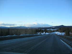
 The landscape is wide open rolling mountains, as with yesterday 95%
is covered by trees.
For part of the trip we see lots of dead conifers, I think it must
be pine beetle. The wood is of no use to the lumber industry, as it
has no structural integrity. The wood is supposed to get a blue
tinge to it and is being used for artisanal pieces, often called
denim pine. BC Hydro is looking to use the wood fibre for power
generation. Just to give you an idea of the scale of the problem,
there is about 800 million cubic metres of infested wood.
The landscape is wide open rolling mountains, as with yesterday 95%
is covered by trees.
For part of the trip we see lots of dead conifers, I think it must
be pine beetle. The wood is of no use to the lumber industry, as it
has no structural integrity. The wood is supposed to get a blue
tinge to it and is being used for artisanal pieces, often called
denim pine. BC Hydro is looking to use the wood fibre for power
generation. Just to give you an idea of the scale of the problem,
there is about 800 million cubic metres of infested wood.
The roads are getting worse and worse, almost like the I5. Given the
low volume of traffic and freezing weather, I’m not surprised.
There’s rarely a town, and even rarer a traffic light. We see folks
out for a stroll along the highway, some are hitchhiking, but
there’s no habitation anywhere near, no idea where they have come
from. They must be a mess from road splash (melted slush on the
edges of the road) by the time they get off the road.
The first main town we reach is
Vanderhoof, labeling itself as the
“Geographic centre of BC”. And we feel like we’ve driven to the
northern extremities! It’s a mennonite community, reminds me of 100
Mile House (not a plus point).
By late afternoon we reach Smithers. We are now in the bottom of a
very wide valley, with a ski resort nearby. It’s a nice little town
(pop:5,500), with a beautiful backdrop of mountains. It somehow has
a sense of community, we find out there is a substantial dutch
community here. We stay at the Hudson Bay Lodge.
Tuesday 23rd
Fortified with nutritious canadian staple, Tim Hortons, we leave for
Terrace. We have business here, otherwise we would never stop,
enough said. The drive on to Prince Rupert is supposed to be
amazing. The road descends down to the Skeena River and then follows
it out to sea, stopping at Prince Rupert! As the mountains close in,
you follow along the bottom of the gorge created by the Skeena
River. Unfortunately rain and fog are conspiring against us. Even so
the glimpses of mountains through the gaps in the fog/clouds make
for dramatic scenery. We can see the massive river, which must be
tidal here. We can see big ice flows sitting on the river bed,
waiting to be taken out to sea when the tide comes in.
 It’s only 2 ½ hours. We arrive in Prince Rupert in the rain, the
norm I understand. We go to the Visitors’ Info Centre, not quite the
same effusive greeting as in PG: Prince Rupert is on an island – Keian Island; everything is closed until summer; you can go for a 1
hour walk (in the rain) out to Butze Point, to watch the Reversing
tidal rapids, you need to go for high tide. Sounds interesting, but
not this time.
It’s only 2 ½ hours. We arrive in Prince Rupert in the rain, the
norm I understand. We go to the Visitors’ Info Centre, not quite the
same effusive greeting as in PG: Prince Rupert is on an island – Keian Island; everything is closed until summer; you can go for a 1
hour walk (in the rain) out to Butze Point, to watch the Reversing
tidal rapids, you need to go for high tide. Sounds interesting, but
not this time.
We check out the Crest and Coast hotels, settling on the latter,
great service and cheaper. The room is “Petite” but clean, cozy and
has a great view.
Dinner is across the road at the aptly name restaurant, Rain. The
owners opened and ran Brass Monkey on Denman Street in Vancouver; we
have a good meal in a fun atmosphere.
Click her for a photo gallery of Prince Rupert to Terrace
Wednesday 24thWe wake up to more of the same. It’s not that cold, locals say it’s always warmer here than inland. Shouldn’t be surprised, it’s like being back home on the Sunshine Coast, just expected it to be colder so far north. We decide to stay until the weather breaks tomorrow. No rush to load the car and get to the next town then, phew!
 We go for a drive around town, it’s not too big (pop:15,000), but
has everything to be a self contained community. The nearest
community (and gas station) is Terrace, 135km away, and it certainly
wasn’t a heavily traveled road yesterday.
We go for a drive around town, it’s not too big (pop:15,000), but
has everything to be a self contained community. The nearest
community (and gas station) is Terrace, 135km away, and it certainly
wasn’t a heavily traveled road yesterday.Prince Rupert had been shrinking in population through the late 90’s. Hopefully with the new container port coming online this summer/fall, and the cruise ships, this will help boost the local economy. The container port is a major deal – it’s bigger than the 3 Vancouver Ports combined. The advantage is that Prince Rupert is nearer Asia and the train link east is just as good, if not better. It’s the same train track that goes through Prince George and Jasper across the Prairies to the St Lawrence Seaway. Prince Rupert is also a major ferry terminal for Alaska and Vancouver Island. It’s also the only way you can get across to the Queen Charlotte Islands – a reason to return here in its own right.
 About 15km away is a small bedroom community,
Port Edwards, the
visitor info centre had said “don’t bother”, but what do we have to
lose. It’s so small; it’s combined with Prince Rupert in the census.
Looks like the community was built in the 50s or 60s and not much
has happened since. We drive through, seeing a sign for a heritage
cannery at the end of the road. It reminds us of Tofino, on the west
coast of Vancouver Island, the trees, the air, the sea and islands,
impromptu streams everywhere. The Cannery, about 15 minutes drive,
is closed for the season, but we stop and look from outside. This
road will be flooded by evening.
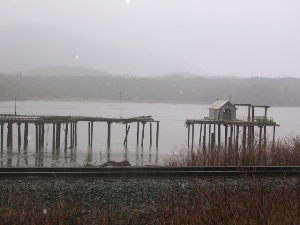
About 15km away is a small bedroom community,
Port Edwards, the
visitor info centre had said “don’t bother”, but what do we have to
lose. It’s so small; it’s combined with Prince Rupert in the census.
Looks like the community was built in the 50s or 60s and not much
has happened since. We drive through, seeing a sign for a heritage
cannery at the end of the road. It reminds us of Tofino, on the west
coast of Vancouver Island, the trees, the air, the sea and islands,
impromptu streams everywhere. The Cannery, about 15 minutes drive,
is closed for the season, but we stop and look from outside. This
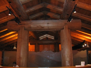
road will be flooded by evening.We return to Prince Rupert, where we visit the North BC Museum. We’re pleasantly surprised; it’s a beautiful building, with interesting displays.
Dinner is at Opa, a japanese restaurant, not bad, especially considering where we are. At last the rain stops. Given that there is an Opa in Gibsons on the Sunshine Coast, M jokingly suggests it is a chain. To our amazement we later discover that it is indeed run by the guy who had initially owned the Gibsons Opa.