My Canada - US Travels
BC - Winnipeg
Winnipeg - Quebec
Quebec - Winnipeg
Winnipeg - BC
Epilogue
North West Drive
Washington
Oregon
California
Nevada
Utah
Colorado
Utah again
Idaho & Montana
Alberta
BC
Epilogue
BC Interior
Langley Detour
Okanagan
Cariboo
Prince George to Prince Rupert
Return to Vancouver
Epilogue
Prince Rupert back home
Thursday 25th
It’s a crisp and clear morning, with a few wisps of cloud. Good, we
have a long drive ahead, and we’re making an early start. We had
considered taking the overnight ferry down to Port Hardy, at the
northern end of Vancouver Island. You need to book several weeks in
advance, there are only about one or two trips a week. However, my
lack of sea legs and the inclement weather would result in frequent
trips to the side of the ferry . . . In the words of the BC Ferries’
guy “If you get seasick, you will on this trip”.
Click her for a photo gallery of Prince Rupert to Terrace
 This time driving to
Terrace we see the valley in it’s full glory.
We stop several times just to take it in; driving with the window
open to take photos gets bloody cold. This is by far the most
spectacular scenery on our drive.
This time driving to
Terrace we see the valley in it’s full glory.
We stop several times just to take it in; driving with the window
open to take photos gets bloody cold. This is by far the most
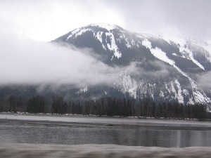
spectacular scenery on our drive.The river must be over a kilometre wide, the mountains are awesome, their steep sides coming straight down and disappearing in the water. “Don’t Stop, Avalanche Area”, No surprise there. We follow close to the river and train tracks from Prince Rupert for the first 30k. The trees on the coast always look different, they’re not upright and having a defined shape, but more huddled and wispy, their shape softened by the occasional moss hanging from branches.
As we approach Terrace the valley opens, and this time we can see that the town is sitting in a big bowl. The valley continues to open up. At one point we stop by the roadside to change drivers, I get out of the car and realize we are driving along a skating rink of black ice. I can’t believe it isn’t more obvious driving. After about 90 Km we pass Kitwanga, the road to Alaska, highway 37. At this point we’re on the same latitude as Ketchikan. Next time we’ll take this and go north to Telegraph Cove. We pass a cyclist out for some fresh air, in the middle of nowhere, cycling on the FROZEN hard shoulder.
 About 80km further on is the small town of Moricetown. As I think I
mentioned, wood is everywhere, forests and forests, mega lumber
yards, every truck. So what would go down as the avant garde use of
materials in Vancouver, here is just the practical solution – a
stunning cedar gas station!!!
About 80km further on is the small town of Moricetown. As I think I
mentioned, wood is everywhere, forests and forests, mega lumber
yards, every truck. So what would go down as the avant garde use of
materials in Vancouver, here is just the practical solution – a
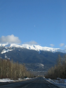
stunning cedar gas station!!!On to Smithers for lunch. We’ll at least stop at a great deli for “lunch to go”, their smoked sausages are amazing. The setting is amazing, weather is beautiful. The valley floor must be 5-10 kilometres wide by now. The locals say the weather “it’s normally like this” . . . There’s a TV show called ‘My name is Alice’, based on the books by Susan Juby and is set in Smithers. But everything is filmed in Vancouver; just the scenes are shot up here – no doubt the same as Elmo, Alaska.
A lot of the towns we are going through are small and unexciting (unless you live there of course). They all seem to survive solely because of the logging industry. With demographic changes and perhaps migration of some logging industry, I wonder if all these towns will still be here in 10-15 years . . . (makes me think of Cisco, down in Utah)
We get into Prince George early evening, and check into the Treasure Cove Hotel – it’s on the edge of town, right on the corner of the highway 16 (Tete Jaune) in from Prince Rupert and the highway 97 down to Williams Lake. Yet again another casino/hotel this time much newer and “hermetic” in style than the Billy Barker in Quesnel.
Fri 26th
It’s another long drive day, just heading back ASAP now, well not quite; we need to return to Kelowna for business. So highway 97 down, Quesnel, Williams Lake, 100 Mile House and finally Cache Creek. We’re now in striking range of the Okanagan or Vancouver.
 Instead of heading back to Kamloops and down, we take the old
Highway 1. This highway was the main way through the Rockies down to
the Lower Mainland and Vancouver, before the Coquihalla Highway was
built (started 1978). The old highway follows the winding Thompson
River below, the terrain has changed from snow covered tree covered
rolling hills to rugged desert. At the town of Spences Bridge, we
cross the Thompson River and turn east on to highway 8 towards
Merritt. The highway follows the Nicola River; it’s a beautiful
winding quiet canyon. The first vehicle we see is after 20km, it’s
not a road I would want to take after a snowfall.
Instead of heading back to Kamloops and down, we take the old
Highway 1. This highway was the main way through the Rockies down to
the Lower Mainland and Vancouver, before the Coquihalla Highway was
built (started 1978). The old highway follows the winding Thompson
River below, the terrain has changed from snow covered tree covered
rolling hills to rugged desert. At the town of Spences Bridge, we
cross the Thompson River and turn east on to highway 8 towards
Merritt. The highway follows the Nicola River; it’s a beautiful
winding quiet canyon. The first vehicle we see is after 20km, it’s
not a road I would want to take after a snowfall.After 80km or so, we reach Merritt, drive straight through and take the 97c connector across to Kelowna. This time we manage to stay at the Manteo for two nights before driving home on the Sunday.