My Canada - US Travels
BC - Winnipeg
Winnipeg - Quebec
Quebec - Winnipeg
Winnipeg - BC
Epilogue
North West Drive
Washington
Oregon
California
Nevada
Utah
Colorado
Utah again
Idaho & Montana
Alberta
BC
Epilogue
BC Interior
Langley Detour
Okanagan
Cariboo
Prince George to Prince Rupert
Return to Vancouver
Epilogue
Okanagan
Tuesday 16th
We leave Langdale, heading for Clinton, a short distance away at the
southern tip of Whidbey Island. Useless facts: Whidbey Island is the
longest island off continental US. From Clinton we take the twice
hourly ferry across to Mulkiteo. It’s a whacking US$6 or so, for the
car and 2 passengers for the 15 minute ride.
We get straight on the I5 and start for the border, stopping only at
Fairhaven for lunch. It’s a quaint town, with great old brick
buildings and some interesting shops. There’s obviously lots of
renovation/construction going on. We eat at the Big Fat Fish Co,
have a good meal and wander around the town. Wouldn’t mind coming
back for 2 days.
Crossing the border is so fast that by the time we show our
passports, we are through.
Once in Vancouver, we check in at the Wedgewood. As usual M finds a
great deal, or there is no way we would be staying at Vancouver’s
best boutique hotel. Their rooms are gorgeous; their spa is small
but elegant; they have the trendiest hotel bar in town, busy at all
times of day; Bacchus, their restaurant has got more acclaims, with
its new chef - ex Claridges (worked under John Williams).
Then off to the reason for returning to Vancouver, the Oyster and
Wine Tasting at the Hyatt, put on by Liberty Wines.
Wednesday 17th
 A fair drive today for the southern part of the Okanagan. The roads
are looking pretty snow covered. We set off early for Hope, at the
east end of the Fraser Valley / Lower Mainland and the start of the
mountains. From here, we take the quiet Highway 3 road through
Manning Park. It’s covered in compact snow, but the road’s so empty
and wide, you drive in the middle anyway!
A fair drive today for the southern part of the Okanagan. The roads
are looking pretty snow covered. We set off early for Hope, at the
east end of the Fraser Valley / Lower Mainland and the start of the
mountains. From here, we take the quiet Highway 3 road through
Manning Park. It’s covered in compact snow, but the road’s so empty
and wide, you drive in the middle anyway!
At the far end of the valley is the town of Keremeos. This is in the
Similkameen Valley, and abuts the Okanagan. We get out and have a
look at the town, not much to see. From here the road splits to head
south to Osoyoos, by the US border, or north towards Penticton, at
the southern end of the Okanagan Lake.
We take a short detour towards Osoyoos, to see the nearby town of
Cawston. It makes Keremeos look like a metropolis; in fact we drive
through Cawston, without realising it. Back track and drive to
Penticton, where we check in at the Ramada.
Thursday 18th
 We wake up to snow and more coming, we drive the hour or so south of
Penticton, to the small town of Oliver in the heart of the southern
Okanagan wine country, for business. They are looking to build a big
wine complex in the town, to promote the industry and the town,
probably several years out yet. The valley is covered with either
vineyards, or orchards (probably soon to become vineyards a la
Napa). They climb up the sides of the valley until the land becomes
desert.
We wake up to snow and more coming, we drive the hour or so south of
Penticton, to the small town of Oliver in the heart of the southern
Okanagan wine country, for business. They are looking to build a big
wine complex in the town, to promote the industry and the town,
probably several years out yet. The valley is covered with either
vineyards, or orchards (probably soon to become vineyards a la
Napa). They climb up the sides of the valley until the land becomes
desert.
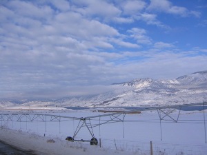
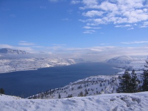
Half an hour or so, further on south and we reach the (retirement)
town of Osoyoos, a few kilometers from the US border. By now, the
whole area is almost desert. From here we head east towards Nelson.
Once across the bottom of Skaha Lake and the line of cheap “Summer
Hotels” the road climbs dramatically out of the Okanagan Valley. The
view at the top is amazing, lots of land is for sale to develop up
here. Just as well that part of the road has been well cleared of
snow.
 Now above the valley, the road is less well cleared of snow. The
hour and a quarter journey to Greenwood, becomes nearer two.
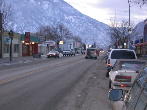
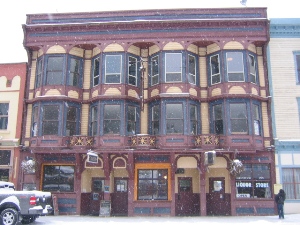
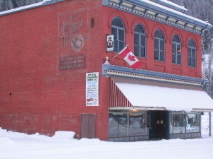
Greenwood is a small community of 1000 people with a nearby bedroom
community, Midway, of another 1000. The town is not much more than
one street, but the buildings are beautiful turn of the century
edifices, in good shape, the exteriors at least. Half the main
street is probably heritage buildings. The town is in a small
valley, like many communities in the Rockies, but the valley is
narrow, so it feels a little oppressive in the town. The film ‘Snow
Falling on Cedars’ was filmed here.
Now above the valley, the road is less well cleared of snow. The
hour and a quarter journey to Greenwood, becomes nearer two.
Greenwood is a small community of 1000 people with a nearby bedroom
community, Midway, of another 1000. The town is not much more than
one street, but the buildings are beautiful turn of the century
edifices, in good shape, the exteriors at least. Half the main
street is probably heritage buildings. The town is in a small
valley, like many communities in the Rockies, but the valley is
narrow, so it feels a little oppressive in the town. The film ‘Snow
Falling on Cedars’ was filmed here.
After visiting the Copper Eagle Coffee Shop and speaking with the
owners, we head back to Penticton the same way we came. But more
carefully, with several inches more snow on the road.
Friday 19th
We leave Penticton and head north to the number 3 city in BC -
Kelowna - with a population of under 100,000 (and it’s booming)!
Driving along the west side of Lake Okanagan through Peachland,
Summerland and the originally named town of Westbank takes about 45
minutes. We pass by lots of orchards, fruit stalls (closed for the
season) and, police speed traps.
Well actually the speed traps aren’t there this time, but whenever
we’re here in summer, this stretch is crawling with them. It’s the
only north/south road in the valley and frequently goes through
small towns. It must be nice pickings for reaching someone’s quota.
Westbank is across from Kelowna, on the west bank (duh!) of Lake
Okanagan. It’s a sizeable city, for being what looks like just an
overflow of Kelowna. The bridge to Kelowna reminds me of the Lions
gate Bridge in Vancouver. Not because of the majestic suspension
bridge coming out of Stanley Park (the Kelowna bridge spends most of
it’s time only a few metres above the water).
 But because of the silly 3 lanes of traffic, with the perpetual
changing direction of the centre lane. Fortunately however The
Kelownites/Kelownians/Someone enlighten me have sensibly started to
build another bridge next to the old one. Completion is summer ’08 I
think.
But because of the silly 3 lanes of traffic, with the perpetual
changing direction of the centre lane. Fortunately however The
Kelownites/Kelownians/Someone enlighten me have sensibly started to
build another bridge next to the old one. Completion is summer ’08 I
think.
Unlike in Vancouver - here comes a Rant – where instead of improving
traffic flow over the Burrard Inlet, it was felt $250 million would
be better spent saving some trees and making some cosmetic upgrades
to the bridge. They widened the lanes (admittedly narrow) and made
some nice side walks. As it was, the project almost came to a
standstill because of widening the lanes; a whole 22 trees had to be
cut down in Stanley Park. Let’s put this in perspective, last month
over 3000 trees were destroyed in the park by winter storms.
Admittedly, there were 4 self interested, bureaucratic organizations
(that I know of) required to make the decision, Vancouver City, West
Vancouver City, BC Parks and the Provincial Government. And we know
that the latter would rather waste $400 million on some redundant
ferries to be later sold off for $20 million. The only winners were
West Vancouver, who basically didn’t want more people coming over to
their side of the shore. Though with the Winter Olympics in 2010,
that shows the usual myopic approach of west coast politicians. Rant
over.
Having crossed the bridge into Kelowna, we have lunch at the
Eldorado hotel. It’s by the water, on the southern side of Harvey
Street, the main drag in town. The hotel is a lovely old building,
with a modern addition, about the same size again. It was renovated
a few years ago, but inside the layout of the public space is so
odd, having lots of dead space. It could have such a great
atmosphere, but nothing flows. The dining room has a great setting,
with good food, unfortunately the service is somewhat “asleep” and
it’s expensive.
After lunch and some business, we head to Kamloops. We take the
route via Vernon and Falkland, rather than take the “Connector” 97C
to the Coquihalla and north. It probably takes longer - 2 ½ hrs in
the snow – but it’s a more interesting drive.
 We arrive early enough to look around Kamloops. Normally Kamloops is
just a place to stop en route through the Rockies, so we’ve never
been in the town. Downtown is much bigger than we expect, maybe even
3 x 4 blocks that’s interesting to walk around. But the weather is
even more miserable, so we’ll settle for driving around.
We arrive early enough to look around Kamloops. Normally Kamloops is
just a place to stop en route through the Rockies, so we’ve never
been in the town. Downtown is much bigger than we expect, maybe even
3 x 4 blocks that’s interesting to walk around. But the weather is
even more miserable, so we’ll settle for driving around.
We stay at one of the many hotels on the highway, just outside
Kamloops (accommodating people who need “just a place to stop en
route through the Rockies“), the Hampton Court. The room is good;
clean, well equipped, quality linen, reasonable price. And it’s only
a few hundred metres from Starbucks!
As with all our road trips it seems, we pack far too much “Stuff”
and most of it needs to be brought in every night, this is a REAL
drag. If only the car was smaller.
First, we’ve got the cooler bag for picnic/breakfast/tea.
Then there’s the wine we’ve picked up along the way, and since it’s
freezing outside, we can’t leave it in the car.
Obviously far too many clothes, ‘cause we have the space. But we’re
getting wise, we now put half in a plastic bin, which we leave in
the car most of the time.
There’s the laptop. Almost all the accommodations have internet, and
how can anyone possibly live without being “Connected”. Not to
mention, part of the trip is business.
It’s winter; we’re taking some remote roads, so we need an emergency
kit, like blanket, water and power bars, (but no spade & kitty
litter for this time).
Chains – had them for 7 years, never used them, but it gives you the
confidence.
More music than we’ll ever listen to.
Oh, and all the junk we buy on the trip.