My Canada - US Travels
BC - Winnipeg
Winnipeg - Quebec
Quebec - Winnipeg
Winnipeg - BC
Epilogue
North West Drive
Washington
Oregon
California
Nevada
Utah
Colorado
Utah again
Idaho & Montana
Alberta
BC
Epilogue
BC Interior
Langley Detour
Okanagan
Cariboo
Prince George to Prince Rupert
Return to Vancouver
Epilogue
Cariboo and Chilcotin
Saturday 20th
Start the day off with Caffeine, so across the highway to Starbucks,
inside the Chapters. Anyway, the Chapters has a great view of the
city, if only the visibility would allow us to see further than 200
yards. Today we’re going north into the real snow country.
It’s an hour west along highway 1 to Cache Creek. For about half the
journey, Kamloops Lake follows below, before it turns into the
Thompson River. We’re already seeing roadside ads for Historic
Barkerville, an old gold mining town, beautifully preserved, but
still 5 hours drive north of us.
At Cache Creek, Highway 1, or “The Trans Canada Highway” heads
south, following the Thompson River. The Coquihalla following
parallel on the other side of the canyon has taken most of the
traffic away from this road. Cache Creek, calling itself “Gateway to
the North”, ‘cause it is really, looks like just a collection of gas
stations. Leaving town we see the Bonaparte Indian Band winery - all
sold out!
 After a little over an hour we reach
100 Mile House (pop: about
2,000), stop for lunch in the best we can find – Smittys. There
isn’t much here, it just seems to be a place to refuel body and
vehicle. I’m now into new territory, only having got as far north as
70 mile house before.
After a little over an hour we reach
100 Mile House (pop: about
2,000), stop for lunch in the best we can find – Smittys. There
isn’t much here, it just seems to be a place to refuel body and
vehicle. I’m now into new territory, only having got as far north as
70 mile house before.
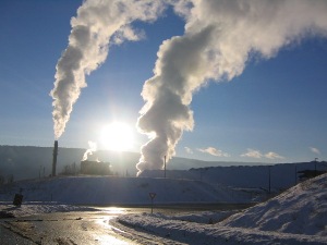
After another hour and a bit we reach Williams Lake (pop: 11,000).
Now I feel like we’re getting into serious lumber country. We
accidentally drive along Mackenzie Avenue to the lumber processing
plant at the north end of the city. I’ve never seen so many felled
trees before, and that’s just the wood I can see, poking through the
snow. It feels a big town, with lots going on, not somewhere I’d
necessarily live or visit, but a place to go and pick up supplies.
The land starts out at Cache Creek as fairly flat and open. After
100 mile house it becomes mountainous, and from Williams Lake
becomes massive rolling mountains. The only white is either a lake,
or the few farms beside the road. As the early evening air cools,
mist forms above the fields of snow and periodically drifts onto the
road. Otherwise it’s trees as far as you can see.
We see periodically the train tracks heading up to Prince George.
Back on the Coast we had considered traveling by train.
Unfortunately after checking websites this was neither sensible from
a route or price point of view.
 The routes that
Via, the only regular train service it seems still
operating west of Ontario, are limited to say the least. For
example, in order to get from Vancouver to Prince George you must
take the train to Jasper (way east of where you should have to go).
Overnight (it’s TWO nights on the way back). Take another train west
to Prince George. This is great I’m sure if you are doing a relaxed
holiday in summer around the whole region. In fact why not stay on
the train to Prince Rupert and then take the ferry down to Port
Hardy on Vancouver Island.
The routes that
Via, the only regular train service it seems still
operating west of Ontario, are limited to say the least. For
example, in order to get from Vancouver to Prince George you must
take the train to Jasper (way east of where you should have to go).
Overnight (it’s TWO nights on the way back). Take another train west
to Prince George. This is great I’m sure if you are doing a relaxed
holiday in summer around the whole region. In fact why not stay on
the train to Prince Rupert and then take the ferry down to Port
Hardy on Vancouver Island.
The only other passenger rail service in the area is Rocky
Mountaineer, better known for it’s trip from Calgary to Vancouver,
overnighting in Kamloops. They tried for the first time last year
traveling Kamloops north to Prince George, the route that we are
taking. Unfortunately they only operate in summer and command a
luxury price tag; they’re after the tourist market, not the
commuter. Otherwise it’s just a freight route.
Yet again, another hour and a bit, we arrive in Quesnel
(pop:10,000). The streets are enshrouded in mist, like a London Pea
Souper, but without the pollution. We go to the Best Western first;
it seemed to be the “Least Bad” from TripAdvisor guest comments.
After seeing a room, we decide not to stay, not least the elevator
music being piped down all the corridors, and even audible in the
room.
The most “In your Face” building as you drive around town is the
Billy Barker Casino Hotel. It’s a 1960’s Inn that has gone through
several renovations, inside and out, so that it now resembles a
paddle steamer all lit up. It’s fun. So against M’s better judgment,
‘cause of the casino we take a look. We get a charming room on the
top floor – we never hear anything from the casino and a fair price.
Accommodation is getting progressively cheaper – 30% cheaper than
Kamloops, which was 20% cheaper than Kelowna! The place has
character, in a good way. Billy Barker was the man who put the area
on the map for gold mining. He later had the town of Barkerville
named after him. We’re going there tomorrow.
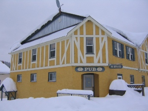
We drive across to West Quesnel for dinner in a pub – quiet,
reasonable food, just took for ever to get the food – as if we have
anything else to do.
Sunday 21st
 The snow is coming down thick and fast. We check out early, we are
going to the big metropolis of Wells (pop: 200-300, no I'm
not missing a zero). It’s 75km away
and there’s very little else on this road, so we doubt it will be
terribly clear or well traveled. We’re right, what fun!
The snow is coming down thick and fast. We check out early, we are
going to the big metropolis of Wells (pop: 200-300, no I'm
not missing a zero). It’s 75km away
and there’s very little else on this road, so we doubt it will be
terribly clear or well traveled. We’re right, what fun!
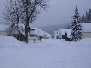
Wells is a beautiful quaint toy town from the 1930s gold mining era.
Did I mention, in the middle of nowhere. It’s where the Buckley
brothers, of Buckley’s Cough Syrup, hail from. LOTS of snow! In fact
the area is known for being a ski-doo paradise, not that we hear
them. We did pass a small ski hill, about 15km before getting to
Wells. There are few businesses, only one restaurant open, the main
place seems to be the Wells Hotel. The place seems to rely on
tourism, being the gateway to the Bowron Lakes and Barkerville. Both
of these places as we are about to find out are only open in summer,
and out of season there is absolutely NO ONE there.
We look around the Wells Hotel, it’s beautifully restored, 14 rooms
I think, with a great hot tub on the roof. After lunch we drive
about 15 minutes further to the end of the road – Bakerville. The
town is CLOSED (until May 16). The only vehicles are those of ski-dooers.
We’re here anyway, so we walk around the deserted town.
 It’s buried in several feet of snow, except the main paths, no doubt
for ski-doos and winter maintenance. From what little we can see,
it’s like Wells, another beautiful old reconstructed town. It’s very
popular in summer, with lots of outdoor shows and the ilk. Bowron
Lakes nearby - we are not going to, because nothing is there - is a
series of lakes people canoe or kayak around, portaging between
lakes and a week later ending up where they started. It is extremely
popular and you need to book a launch time. Seems like the West
Coast Trail (Port Renfrew - Bamfield on the west coast of Vancouver
Island), or at least a water based version of it.
It’s buried in several feet of snow, except the main paths, no doubt
for ski-doos and winter maintenance. From what little we can see,
it’s like Wells, another beautiful old reconstructed town. It’s very
popular in summer, with lots of outdoor shows and the ilk. Bowron
Lakes nearby - we are not going to, because nothing is there - is a
series of lakes people canoe or kayak around, portaging between
lakes and a week later ending up where they started. It is extremely
popular and you need to book a launch time. Seems like the West
Coast Trail (Port Renfrew - Bamfield on the west coast of Vancouver
Island), or at least a water based version of it.
Heading back, the weather has not improved, we don’t see a car for
40km, and we’re the only fools out. Once at Quesnel, we continue our
drive north to Prince George. It’s only a little over an hour away,
well maybe when the roads are clear.
We check into the Ramada. Swanky looking lobby, but mediocre rooms.
A little incongruous, but fine by us. We try a couple of restaurants
recommended to us, but it being Sunday evening they are closed. We
end up at the Coast Hotel eating in their Tepanyaki Restaurant,
because it is so busy. We have a fun meal. Prince George seems to be
reversing the trend of being “Cheaper the further north you go”. I
suppose if you are known as the “Capital of the North” and booming,
you can afford to be.