|
|
|
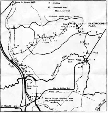
Tampa (3) The Hillsborough County Wilderness Area is comprised of Morris Bridge, Flatwoods, and Trout Creek parks. Rollerblading, biking, and hiking see the most activity on the multiuse trails, 20+ miles of which are off-road. This area has experienced explosive growth in the past few years and there are a lot of trail users. Unless you go at dawn, dusk, or in the rain (or threatening to rain), be courteous to other trail users. Modest entry fee at all parks.
Morris Bridge and Trout Creek Parks Terrain: There are mostly single track trails along or near the Hillsborough River. This area is sandy and drains really well. Biking 24 hours after a rain shower is okay. No hunting. Skill To Get There: Take I-75 towards Tampa. Approximately 6 miles north of I-4 exit on Fletcher Avenue (582-A). Head east on Fletcher for about 1/2 mile. The Trout Creek entrance is on the north side of the road (see blue arrow in photograph below). Continue east for another 1/10th of a mile and the Morris Bridge dirt road entrance will be on the south side of the road (see yellow arrow in photograph below). Continue east on Fletcher for about 5 miles, crossing the Hillsborough River to the Morris Bridge main entrance. The park is on the west side of the road.
Morris Bridge offers paved, single track, and double track trails open to bicycles. Water, restrooms, and bike washes are available at Trout Creek Park and at the main entrance of Morris Bridge. The single track can be technical in a few spots, mostly in the form of roots. Generally, however, trails are easy to moderate in difficulty and offer no surprises.
At Morris Bridge (opposite the Trout Creek entrance) you'll find trail info and a map in a kiosk near the picnic tables like the ones pictured here. Print these maps out or make a quick sketch so you don't get lost. Try not to stray off course because it's notoriously easy to get lost. Trails are well marked, but some intersections do not occur with the main trail so you are left guessing which way to go. Some loops criss-cross each other making it more difficult to locate where you are and you may end up going in circles. So if you're not familiar with the trails, write down which fork you choose. You can follow your notes back to the entrance. In this area trails are flat, but curvy and fun. Beginners can handle the trails, but advanced riders won't be exceedingly bored. South and southeast trails are more technical and are named appropriately (i.e. Gatorbait). If you continue on the main trail (north and east), this will take you to the main entrance of Morris Bridge.
Flatwoods Park Terrain: Trails are a mix of paved, single track, and double track trails near the Hillsborough River. Trails drain well and you can ride just one day after after a rain storm. Skill To Get There: Take I-75 towards Tampa. Approximately 7 miles north of I-4 exit on Bruce B. Downs Boulevard. Head east on Bruce B. Downs and within 1/2 a mile a paved parking area will appear on the south side of the road. Basically, at Flatwoods you will find single track similar to the Trout Creek trails south of Fletcher. Heading east will lead you Morris Bridge, while heading south will take you to Trout Creek. The "Flatwoods" name is appropriate since the area is pancake flat, but the trails can still be challenging. During dry spells the challenge is due to the sandy conditions. There is a restroom facility at the parking lot, but water and restrooms are also available periodically on the 10+ miles of paved sections. The paved loop surrounds off-road trails (Flatwoods), which are marked. The section of the paved loop that is furthest east leads to Morris Bridge. Off road trails continue south and west across Morris Bridge road. From the Flatwoods trailhead head south to a wide, unshaded double track trail along a dike, leading to Trout Creek. Just north of Trout Creek park the dike leads to a dam, and just west of the dam there is access to the Tampa Palms paved and unpaved trail network. Bike down the hill next to the river heading west and pass under I-75. Tampa Palms trails meander around neighborhoods and are mostly paved. The unpaved trails are very short, and are supposed to be for residents and their guests only. See the Manatees Tampa Electric Company (TECO) uses sea water to cool its operations. This water is returned to the sea at a slightly warmer temperature than surrounding waters, attracting manatees in cooler weather. Tampa manatee viewing occurs between November and April. Viewing is open from 10am to 5pm. Call 813-228-4289 for more details.
Best way to bike from downtown Tampa to USF, Tampa Palms, or Temple Terrace You've gotta be hard core to do this, but... This route is like a ladder and it will seem like you're climbing steps, but it is the safest way to deal with traffic. From downtown, find Florida avenue and head north under the interstate. Turn right on an east-west corridor such as Martin Luther King or the next major road. Turn left to head north on Central. Turn right to head east on Hanna. Turn left to head north again on 22nd Street. Turn right to head east on Sligh Avenue. Cross the railroad tracks and turn left on Rowlett to head north. There will be a park and follow the outskirts on River View and Yukon, which runs east-west. Turn left to head north on 40th Street. This will take you past the theme parks and to USF. The rest is simple! Would you like to get involved in the Bicycle and Pedestrian Advisory Council (BPAC) of Tampa? The Hillsborough Metropolitan Planning Organization (click on Meetings, then Calendar) has information on where and when this group meets. Voice your concerns and volunteer for projects here. |